Fensfjorden
| Fensfjorden | |
|---|---|
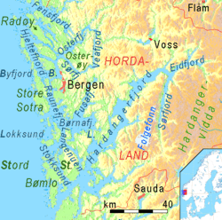 Map of the fjord, north of Bergen | |
| Location | Sogn og Fjordane and Hordaland counties, Norway |
| Coordinates | 60°46′53″N 5°11′01″E / 60.7813°N 5.1835°ECoordinates: 60°46′53″N 5°11′01″E / 60.7813°N 5.1835°E |
| Primary inflows | Masfjorden and Austfjorden |
| Primary outflows | North Sea |
| Basin countries | Norway |
| Max. length | 30 kilometres (19 mi) |
| Max. width | 3 to 5 km (1.9 to 3.1 mi) |
Fensfjorden is a fjord on the border of Hordaland and Sogn og Fjordane counties in Norway. The 30-kilometre (19 mi) long fjord begins in the North Sea at Holmengrå Lighthouse and flows to the southeast through the municipalities of Austrheim, Gulen, Lindås, and Masfjorden. The fjord ends on the Masfjorden-Lindås border where it splits into two fjords: Masfjorden (which flows to the northeast into Masfjorden municipality) and Austfjorden (which flows southeast into Lindås municipality).
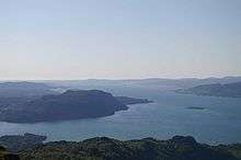
The fjord is generally about 3 to 5 kilometres (1.9 to 3.1 mi) wide. There is only one crossing: a car ferry from Støvåg in Gulen to Mongstad in Lindås. The islands of Byrknesøyna, Mjømna, and Sandøyna (as well as the mainland) lie on the northern side of the fjord. The south side of the fjord includes the island of Fosøyna and the Lindås peninsula lie on the south side of the fjord.[1]
There is a lot of ship traffic in the outer part of the Fensfjorden due to the large oil refinery and industrial area at Mongstad on the northern end of the Lindås peninsula. Mongstad is Norway's largest port based on tonnage, and Northern Europe's largest oil port. Roughly 2000 ships port at Mongstad in the Fensfjorden annually.[2]
See also
References
- ↑ Store norske leksikon. "Fensfjorden" (in Norwegian). Retrieved 2014-01-03.
- ↑ "Statoil Mongstad" (in Norwegian). Austrheim kommune. Archived from the original on 2007-09-27.