Feijenoord district
| Feijenoord | |
|---|---|
 | |
| Country |
|
| Province | South Holland |
| City | Rotterdam |
| Area | |
| • Total | 2.49 sq mi (6.44 km2) |
| Population (2004) | |
| • Total | 72.320 |
| • Density | 37.54/sq mi (14.493/km2) |
| Time zone | UTC+1 (CET) |
Feijenoord (Dutch pronunciation: [ˈfɛi̯əˌnoːrt]), not to be confused with the neighbourhood Feijenoord (which is located in the Feijenoord district) is a district in Rotterdam and is located south of the Nieuwe Maas. As of 1 January 2004 there were 72.320 citizens. The area is 6.44 km² (1.45 km² of this is water). It is not the home of the city's main football club, Feyenoord, which is situated in the neighbouring township of IJsselmonde.
The district gained significance in the 19th century as a centre of shipbuilding, principally at the Fijenoord yard.
Neighbourhoods in Feijenoord
Ethnicity
The majority of the population of Feijenoord are immigrants, approximately 36% of the population are Dutch natives, 8% are western immigrants and 56% are non-western immigrants. The biggest non-western immigrant groups are Moroccan (10%), Netherlands Antillean (4%), Surinamese (11%) and Turks (19%).[1]
Problematic neighbourhoods
According to a list made by Eberhard van der Laan (State Secretary of infrastructure), 4 out of the 8 neighbourhoods in Feijenoord are amongst the most problematic neighbourhoods in The Netherlands.[2] The neighbourhood Bloemhof ranks at number 4 on the list, making it the most problematic neighbourhood in its district and the second in the south of Rotterdam, followed by Hillesluis at rank 13, Afrikaanderwijk at rank 33 and Vreewijk at rank 44.[3]
Poverty
Around 29% of the total population of Feijenoord lives on welfare, while the average of Rotterdam is 21%.[4] Neighbourhoods such as Bloemhof and Hillesluis have an unemployment rate above 40%,[5] which is a lot higher than the average of Rotterdam (13%) and The Netherlands (6%). 63% of the population of Feijenoord is low educated (which may be a reason for the insane poverty), compared to a Rotterdam average of 49%.[6]
Images
 Putsebocht in Bloemhof
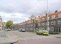
 Beijerlandselaan in Hillesluis
 Church in Vreewijk
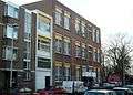 Protestant school from 1909 in Afrikaanderwijk
 Lange Hilleweg in Bloemhof
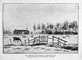 'Pesthuis' from 1804 in Feijenoord
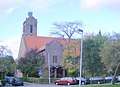 Orthodox church in Vreewijk
References
- ↑ http://www.ggdrotterdamrijnmond.nl/onderzoek/professionals/gezondheid-in-kaart/rapporten-2010.html?tx_rkdownload_pi1%5Bfileid%5D=854&cHash=22359170ec4fc72451539394949f8284
- ↑ http://www.liwwadders.nl/van-der-laan-maakt-hele-lijst-probleemwijken-bekend/
- ↑ http://www.liwwadders.nl/van-der-laan-maakt-hele-lijst-probleemwijken-bekend/
- ↑ http://www.ggdrotterdamrijnmond.nl/onderzoek/professionals/gezondheid-in-kaart/rapporten-2010.html?tx_rkdownload_pi1%5Bfileid%5D=854&cHash=22359170ec4fc72451539394949f8284
- ↑ http://www.rijnmond.nl/nieuws/7058/10-000-huishoudens-Feijenoord-onder-armoedegrens
- ↑ http://www.ggdrotterdamrijnmond.nl/onderzoek/professionals/gezondheid-in-kaart/rapporten-2010.html?tx_rkdownload_pi1%5Bfileid%5D=854&cHash=22359170ec4fc72451539394949f8284
External links
Boroughs of Rotterdam | ||
|---|---|---|
Coordinates: 51°53′46″N 4°30′50″E / 51.896°N 4.514°E