Farmers Loop, Alaska
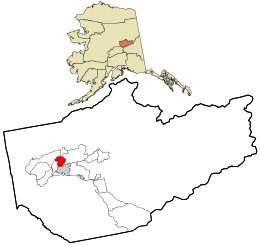
Farmers Loop is a census-designated place in Fairbanks North Star Borough, Alaska, United States, one of several CDPs created out of various Fairbanks suburbs and outskirts during the 2010 census, at which time it had a population of 4,853.[1] The CDP is located due north of Fairbanks and is centered on and named for Farmers Loop Road, a road that runs along the foothills north of Fairbanks between the Steese Highway and the northeastern corner of the University of Alaska Fairbanks campus.
According to the U.S. Census Bureau, the Farmers Loop CDP has a total area of 21.90 square miles (56.71 km2), of which 21.87 square miles (56.65 km2) is land and 0.02 square miles (0.06 km2), or 0.10%, is water.[1]
References
- 1 2 "Geographic Identifiers: 2010 Census Summary File 1 (G001): Farmers Loop CDP, Alaska". American Factfinder. U.S. Census Bureau. Retrieved April 13, 2016.
External links
Municipalities and communities of Fairbanks North Star Borough, Alaska, United States | ||
|---|---|---|
| Cities | 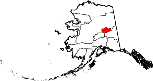 | |
| CDPs | ||
| Unincorporated communities | ||
| Ghost town | ||
Coordinates: 64°53′48″N 147°41′39″W / 64.89667°N 147.69417°W