Fangfoss with Bolton
| Fangfoss with Bolton | |
|---|---|
| Civil parish | |
 | |
| Coordinates: 53°58′N 0°50′W / 53.967°N 0.833°WCoordinates: 53°58′N 0°50′W / 53.967°N 0.833°W | |
| Country | England |
| Primary council | East Riding of Yorkshire |
| Region | Yorkshire and the Humber |
| Status | Parish |
| Government | |
| • Type | Parish Council |
| • UK Parliament | East Yorkshire |
| • EU Parliament | Yorkshire and the Humber |
| Population (2011 census)[1] | |
| • Total | 581 |
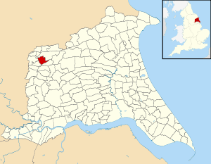
Fangfoss with Bolton is a civil parish in the East Riding of Yorkshire, England. It is situated approximately 11 miles (18 km) to the east of the city of York and 3.5 miles (5.6 km) north-west of the town of Pocklington. It covers an area of 900.98 hectares (2,226.4 acres).[2]
The civil parish is formed by the villages of Fangfoss and Bolton. According to the 2011 UK census, Fangfoss with Bolton parish had a population of 581,[1] a decrease on the 2001 UK census figure of 602.[3]
References
- 1 2 UK Census (2011). "Local Area Report – Fangfoss Parish (1170211178)". Nomis. Office for National Statistics. Retrieved 18 February 2018.
- ↑ "2001 Census Area Profile" (PDF). East Riding of Yorkshire Council. 2004. Archived (PDF) from the original on 18 March 2012. Retrieved 8 February 2013.
- ↑ "2001 Census: Key Statistics: Parish Headcounts: Area: Fangfoss CP (Parish)". Neighbourhood Statistics. Office for National Statistics. Retrieved 12 March 2008.
- Gazetteer — A–Z of Towns Villages and Hamlets. East Riding of Yorkshire Council. 2006. pp. 4–5.
External links
![]()
This article is issued from
Wikipedia.
The text is licensed under Creative Commons - Attribution - Sharealike.
Additional terms may apply for the media files.