Eysturoyartunnilin
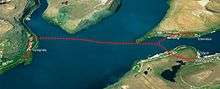 Map of where the Eysturoy tunnel will be situated | |
| Overview | |
|---|---|
| Location | Skálafjørður and Tórshavn, Faroe Islands |
| Status | In progress |
| Operation | |
| Work begun | 2016 |
| Opened | 2019-2020 |
| Operator | P/F Eystur- og Sandoyartunlar |
| Traffic | Automotive |
| Toll | Yes |
| Vehicles per day | estimated 6,000 |
| Technical | |
| Length | 11,240 m (36,880 ft) |
| No. of lanes | 2 |
| Operating speed | 80 km/h (50 mph) |
| Highest elevation | 15 m (49 ft) |
| Lowest elevation | −187 m (−614 ft) |
| Width | 10.5 |
| Grade | 5.0% (max.) |
Eysturoyartunnilin (or the Eysturoy Tunnel, earlier known as Skálafjarðartunnilin) is a large infrastructure project which will connect the island of Streymoy to the island of Eysturoy through a sub-sea road tunnel under the Tangafjørður fjord in the Faroe Islands. It will also cross the southern part of Skálafjørður and connect the towns of Runavík on the Eastern side and Strendur on the Western side of the fjord. Altogether, the three-branched sub-sea tunnel will be 11.240 kilometres (6.8 miles) long, including an underwater roundabout. Construction costs are estimated to be around 1 billion DKK.[7] Drilling commenced on 21 February 2017[1][2] and the tunnel is to be finished by 2019-2020.[3]. Medio June 2018 the project marked its halfway milestone. [4]
History
The idea for the Eysturoyuartunnil emerged during the construction of the Vága- and Norðoyatunnilin, in 2002 and 2006 respectively, which heralded a new look on domestic transport and regional development. In 2006, the private company P/F Skálafjarðartunnilin was founded to build this tunnel.[5] Due to the financial crisis, it took the stakeholders several years to materialize the plans and get political support.[6] The tunnel has been included in the 2012 national mobility plan, which abandoned the name Skálafjarðartunnilin and now only refers to Eysturoyartunnilin.[7] In June 2013, another private company, P/F Eysturoyartunnilin, was established in order to pursue a deal between the Faroese national government, the Faroese insurance company LÍV and the Danish-owned Copenhagen Infrastructure Partners (CIP). CIP had made secret arrangements with the Faroese minister for transport, Kári P. Højgaard, who had to resign in early September as this came out. This led to a small political crisis. In 2015, after the outcomes of an official inquiry, the cabinet of Kaj Leo Johannesen had to call for early elections.[8][9] Both P/F Skálafjarðartunnilin and P/F Eysturoyartunnilin were liquidated in 2015, after circa two years of idling.[10][11] In the aftermath of the political crisis of 2013 though, a special commission drafted a proposal for a public rather than private solution.[12] This proposal was supported by all parties and led in 2014 to the establishment of a public company, P/F Eystur- og Sandoyartunlar (in short 'EStunlar' or EST).[13][14] This company, owned entirely by the Ministry of Transport, is to build, own and manage both the Eysturoyartunnil and the Sandoyartunnil. NCC was contracted to carry out the construction works, with drilling started on 21 February 2017. The construction work for the Sandoyartunnil will start in 2018.[8]
Further reading
- Theme about the Eysturoy tunnel by the National Broadcasting Service of the Faroe Islands: http://kvf.fo/tema/skalafjardartunnilin
- Documentary by KVF: Skálafjarðartunnilin - kosta hvat tað kosta vil
Construction
On 8 November 2016, a deal was struck with the Scandinavian construction company NCC about constructing the Eysturoy tunnel as well as the Sandoy tunnel. The company will begin with construction on the Eysturoy tunnel, and once the drilling of the Eysturoy tunnel has finished, NCC will start drilling the Sandoy tunnel, whilst finishing off the Eysturoy tunnel. The contract for both tunnels is for 2,073 million DKK, whilst the overall cost for both tunnels is estimated at around 2,600 million DKK.[15]
The construction of the roads leading to the two portals of the Eysturoy Tunnel started early in 2016 near the village of Hvítanes (north-east of Tórshavn), and in the village of Strendur on Eysturoy, where they filled out a part of the sea near land, in order to build a roundabout there, so the traffic from the tunnel can lead to the roundabout.[16][17]
The drilling of the tunnel itself started on 21 February from the Strendur side and on 27 April 2017 from the Hvítanes side. The Strendur team reached the underwater roundabout section on 4 December 2017 [18]. By that day, 3,059 metres had been dug from both sides combined. With the first leg and roundabout completed, a third drilling team started, with two teams on the Hvítanes-roundabout leg (which will meet each other midway) and one from the roundabout to Saltnes. The current planned date of opening is in the second semester of 2019.[19]
11 June 2018, the symbolic halway point was reached when 5,674 meters out of 11,250 combined were drilled. [20]
Specifications
The tunnel will be a two-laned undersea tunnel. It will connect both sides of the bay of Skálafjørður using two tunnels that connect to a roundabout under the seabed at mid-bay. The tunnel will be 2.2 kilometres (1.4 miles) long from the main road at Rókini in Saltnes to the roundabout, and the distance from Sjógv at Strendur to the roundabout will be 1.7 kilometres (1.1 miles). The main tunnel from Tórshavn to the roundabout will be 7.5 kilometres (4.7 miles) and will resurface by the village of Hvítanes.[21] This results in an overall road length of 11.250 metres,[15] making it the longest sub-sea road tunnel in the world. In order to increase safety, no inclination in the tunnel is steeper than 5 per cent and the lowest point is 187 metres (614 feet) below the water’s surface.[21]
Tolls
The tunnel will be repaid through toll fees. Experiences from the Vágar tunnel and the Norðoy tunnel show that traffic in the tunnels is greater than originally expected and the growing number of cars ensures stable funding.[22] [23]The official toll fees are yet to be announced, but first indications read between 50-70 krónur between Eysturoy and Tórshavn (one way), with lower fares for local cross-Skálafjørður traffic.[24]
Impact
When the tunnel is finished in 2019-2020, it will significantly reduce travel times to the capital. The tunnel will shorten the travel distance from Tórshavn to Runavík/Strendur from 55 kilometres (34 miles) to 17 kilometres (11 miles). The 64 minute drive will be shortened to 16 minutes. The drive from Tórshavn to Klaksvík will be shortened from 68 minutes to 36 minutes.[21] Similar to the impacts of the two existing sub-sea tunnels, an intensification of traffic, interaction and regional integration is expected from the increased accessibility, on both the local, regional and national scale.[25]
See also
References
- ↑ Leo, Jens Hákun (17 February 2017). "Fyrsta skotið fyri Eysturoyartunlinum týsdagin" (in Faroese). Portal.fo. Retrieved 17 February 2017.
- ↑ "Spreingja um ein mánað". KVF. Retrieved 2017-01-31.
- ↑ "Eysturoyartunnilin verður liðugur í 2019". Sjovarkommuna. Retrieved 2016-11-17.
- ↑ http://www.estunlar.fo/fo/um-tunlarnar/eysturoyartunnilin/framgongd-vid-boring/
- ↑ "Document on a reply from Rúni B. Róin and Jan Jakobsen on written questions from Elsebeth M. Gunnleygsdóttir" (PDF). Retrieved 2016-11-17.
- ↑ "Timeline of the Eysturoyartunni as of June 2013". Innlendismálaráðið. Retrieved 2016-11-19.
- ↑ "Samferðsluætlan 2012-2024 - Føroyar Sum Ein Býur". Innlendismálaráðið. Retrieved 2016-11-19.
- ↑ From, Lars (23 August 2015). "En tunnel, der kom på tværs" (in Danish). Jylllands-Posten. Retrieved 19 November 2016.
- ↑ Rigsombudsmanden på Færøerne (13 August 2015). (PDF) (in Danish). Rigsombudsmanden http://www.ft.dk/samling/20142/almdel/f%C3%A6u/bilag/4/1540165.pdf. Retrieved 18 November 2016. Missing or empty
|title=(help) - ↑ "P/F Skálafjarðartunnilin liquidated". Retrieved 2016-11-07.
- ↑ "P/F Eysturoyartunnilin liquidated". 8 August 2015. Retrieved 2016-11-19.
- ↑ "uppskot til logtingslog um stovnan av partafelagi at reka undirsjovartunlar". 13 December 2013. Retrieved 2016-11-19.
- ↑ "P/F Eystur- og Sandoyartunlar erected". Retrieved 2016-11-07.
- ↑ "Law on the Eysturoy- and Sandoyartunlar". Retrieved 2016-11-07.
- 1 2 "Sáttmáli undirskrivaður um bygging av... - P/F Eystur- og Sandoyartunlar | Facebook". www.facebook.com. Retrieved 2016-11-17.
- ↑ Abrahamsen, Helgi (15 March 2016). "Eysturoyartunnilin: Byrja at grava Eysturoyarmegin í dag" (in Faroese). Norðlýsið. Retrieved 19 November 2016.
- ↑ Jacobsen, Vilmund (22 February 2016). "Soleiðis sær tunnilsmunnin út" (in Faroese). in.fo. Retrieved 19 November 2016.
- ↑ http://www.estunlar.fo/fo/um-tunlarnar/eysturoyartunnilin/framgongd-vid-boring/
- ↑ http://www.in.fo/news-detail/skjott-opid-millum-strendur-og-toftir/
- ↑ http://www.estunlar.fo/fo/um-tunlarnar/eysturoyartunnilin/framgongd-vid-boring/
- 1 2 3 "The Eysturoy tunnel". Eystur- og Sandoyatunlar. Retrieved 2016-11-17.
- ↑ "THE PROJECT". Eystur- og Sandoyatunlar. Retrieved 2016-11-17.
- ↑ https://drive.google.com/file/d/0B5RKuOQTPJS8VzNtaGFwcWVlWDA/view?usp=sharing
- ↑ http://www.in.fo/news-detail/eru-vid-at-finna-prisin-fyri-at-koyra-igjoegnum-eysturoyartunnilin/?L=hpwggdehduhmo&cHash=20808a894b108d2dfbdee3efd69ca20a
- ↑ https://drive.google.com/file/d/0B5RKuOQTPJS8VzNtaGFwcWVlWDA/view?usp=sharing