Exter (Vlotho)
| Exter | |
|---|---|
| Ortsteil of Vlotho | |
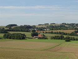 Rural scene with highway bridge in background | |
 Exter Districts of Vlotho 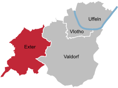  | |
| Coordinates: 52°08′16″N 08°46′48″E / 52.13778°N 8.78000°ECoordinates: 52°08′16″N 08°46′48″E / 52.13778°N 8.78000°E | |
| Country | Germany |
| State | North Rhine-Westphalia |
| Admin. region | Detmold |
| District | Herford |
| Town | Vlotho |
| Elevation | 99 m (325 ft) |
| Population (30 June 2007) | |
| • Total | 3,057 |
| Time zone | CET/CEST (UTC+1/+2) |
| Postal codes | 32602 |
| Dialling codes | 05228 |
| Vehicle registration | HF |
Exter [ˈɛkstɐ] (![]()
Location
Exter borders on Herford in the west, Löhne and Bad Oeynhausen (both Minden-Lübbecke district) in the north, the suburb Valdorf of Vlotho in the east, and Bad Salzuflen (Lippe district) in the south. Bundesautobahn 2 goes through the village.
The highest point is the Steinegge at 255.5 m, the lowest point is at Hagenmühle at 99.6 m.
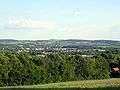 View of Exter from the north – with Wüsten (Lippe) in the background
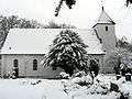 Germany's first Lutheran highway church
 Renovated windmill in Solterwisch
History
The name Exter was first mentioned in the 12th century in a document of the convent in Herford.
Attractions
The windmill built in 1850 in Solterwisch has been renovated and is fully functional.[1]
The Anglican-Lutheran church, built in 1666, was consecrated as the first Anglican highway church in Germany in 1959.[2]
References
- ↑ "Lindemanns Windmühle" (in German). Geschichtswerkstatt Exter. Retrieved 19 May 2010.
- ↑ Steiner, Ralf. "Autobahnkirchen in Deutschland" (in German). Autobahnkirche.de. Retrieved 19 May 2010.
External links
- Geschichtswerkstatt Exter (in German) historical society of Exter
| Authority control |
|---|