Cuckmere Valley
| Cuckmere Valley | |
|---|---|
 Cuckmere Valley Cuckmere Valley shown within East Sussex | |
| Area | 17.6 km2 (6.8 sq mi) [1] |
| Population | 191 (2011)[2] |
| • Density | 30/sq mi (12/km2) |
| OS grid reference | TQ523017 |
| • London | 50 miles (80 km) NNW |
| District | |
| Shire county | |
| Region | |
| Country | England |
| Sovereign state | United Kingdom |
| Post town | POLEGATE |
| Postcode district | BN26 5 |
| Dialling code | 01323 |
| Police | Sussex |
| Fire | East Sussex |
| Ambulance | South East Coast |
| EU Parliament | South East England |
| UK Parliament | |
Cuckmere Valley is a civil parish in the Wealden District of East Sussex, England. As its name suggests, the parish consists of a number of small settlements in the lower reaches of the River Cuckmere.[3]
The settlements
There are three villages within the Cuckmere Valley: Litlington, Lullington and Westdean. Archaeological remains nearer the coast at Exceat suggest a further settlement there in former times.
The civil parish of Cuckmere Valley was created in 1990 when Litlington, Lullington and Westdean parishes were abolished, with small areas transferred between Litlington and Alfriston, which remained a separate civil parish.[4]
Litlington
The name is Saxon, and probably indicates Litl's homestead. The twelfth- century church is dedicated to St Michael the Archangel.
Maria Fitzherbert (1756–1837), mistress of George IV, lived at Clapham House in the village.
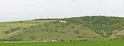
In 1924 a chalk figure of a horse was cut into the downs to the west of the village, replacing one cut in the 19th century.[5] The village inn is the Plough and Harrow.[6]
Lullington
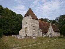
Lullington is the most northerly of the three, about 10 miles (16 km) southeast of Lewes. It lies on a shoulder of the South Downs at the point where the River Cuckmere cuts through the downs, on the opposite bank of the river to Alfriston.[7] A medieval village, Lullington Court, was abandoned after the Black Death in the 14th century; its site was to the east of the present Lullington. The church, dedicated to the Good Shepherd, is believed to be the smallest in England, having been rebuilt using only the original chancel after a fire had destroyed the remainder of the building. Services are held only in the summer months, as the building has no electricity.[8][9]
Exceat
Exceat (pronounced ex-seat) was an ancient village. The A259 goes by it just east of the River Cuckmere. The name may have come from æc-sceat, an oak grove,[10] or from the Old English for "the place of the Aese", early kings of Kent whilst another etymology is possible from Brittonic wysg meaning water or river (or possibly "esgair meaning ridge) and ceat meaning woods, hence "Wooded River" or "Wooded Ridge". After the Norman conquest, the village was given to Robert, Count of Mortain, half brother of William the Conqueror. Both Exceat and the land were given later to Grestein Priory in Wilmington.
Until the 14th century, Exceat was an important village with its own church. The village suffered French raids; it suffered many fatalities during the Black Death, as was effectively abandoned by the 15th century.
The main features are the Visitors Centre for the nearby Seven Sisters[11] and the Cuckmere Inn Public House[12] across Exceat Bridge over the Cuckmere.
West Dean
West Dean (or Westdean) is located on the edge of Friston Forest. Its church is dedicated to All Saints.[13]
Landmarks
The National Trust owns land on the western side of the river south of the A259.
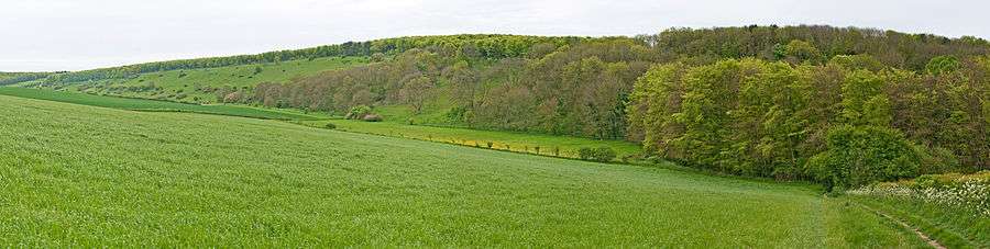
In addition, there are three Sites of Special Scientific Interest within the parish; Seaford to Beachy Head, Wilmington Downs and Lullington Heath. Seaford to Beachy Head is a large site of biological and geological importance. The area contains a wide variety of habitats based on the chalk bedrock, which hosts a wide range of flora and fauna, including some nationally rare species.[14] Wilmington Downs is another area of biological interest; its chalk grassland is habitat for several rare species.[15] Lullington Heath is also of biological interest due to its chalk heath and grassland habitats.[16]
See also
References
- ↑ "East Sussex in Figures". East Sussex County Council. Retrieved 2008-04-26.
- ↑ "Civil Parish population 2011". Retrieved 9 October 2015.
- ↑ Parish Election results (includes map showing location of the parish) Archived 2008-05-15 at the Wayback Machine.
- ↑ "East Sussex Record Office: Guide to records of rating and taxation" (PDF). East Sussex County Council. Archived from the original (PDF) on 2012-04-17. Retrieved 2012-09-02.
- ↑ Short item on history of Littlington Horse
- ↑ "Plough and Harrow". beerintheevening.com.
- ↑ Kelly's Directory of Kent, Surrey & Sussex, 1891 Lullington notes
- ↑ "Lullington Church". alfriston-churches.co.uk. Archived from the original on 2008-05-15.
- ↑ Notes on Alfristion, including further notes on Lullington
- ↑ Ekwall, Eilert (1960). The concise Oxford dictionary of English place-names (4. ed.). Oxford: Clarendon Press. ISBN 0198691033.
- ↑ "Seven Sisters Country Park Visitor Centre". sevensisters.org.uk.
- ↑ "britishpubguide.com". britishpubguide.com. Archived from the original on 2011-09-11.
- ↑ "West Dean". alfriston-churches.co.uk. Archived from the original on 2007-10-07.
- ↑ "Natural England — SSSI (Seaford to Beachy Head)". English Nature. Retrieved 2008-10-03.
- ↑ "Natural England — SSSI (Wilmington Downs)". English Nature. Retrieved 2008-10-03.
- ↑ "Natural England — SSSI (Lullington Heath)". English Nature. Retrieved 2008-10-03.