Ewaninga Rock Carvings Conservation Reserve
| Ewaninga Rock Carvings Conservation Reserve Northern Territory | |
|---|---|
|
IUCN category V (protected landscape/seascape) | |
 Ewaninga Rock Carvings Conservation Reserve | |
| Nearest town or city | Alice Springs |
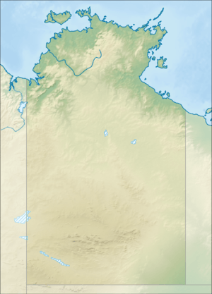
| Coordinates | 24°01′S 133°57′E / 24.017°S 133.950°ECoordinates: 24°01′S 133°57′E / 24.017°S 133.950°E |
| Established | 1970[1] |
| Area | 6 hectares (15 acres)[1] |
| See also | Protected areas of the Northern Territory |
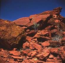
The Ewaninga Conservation Reserve is a protected area in the Northern Territory of Australia consisting of an area of low sand dunes, rocky outcrops and a claypan about 35 kilometres (22 mi) south of Alice Springs. The conservation reserve was gazetted on 20 November 1996. The claypan is a slightly concave surface approximately 100m across. It retains water after even light rain, thus attracting many birds and animals. The claypan and surrounding outcrops are also a significant archaeological site.
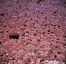
The conservation reserve contains many prehistoric abraded and pecked engravings that provide an outstanding example of central Australian rock art. The main feature of the area is a set of about 1000 petroglyphs, distributed among the rock outcrops to the south and south-east of the claypan. Most of the petroglyphs are non-representational, consisting of circles, lines and other geometric motifs, though there are some examples of animal tracks. The motifs have been compared with those found elsewhere in Central Australia and Tasmania.[2]
Aspects of the petroglyphs such as their motifs and degree of weathering suggest an age as great as 30000 years, although a more precise age is unknown. Flood describes the petroglyphs as Panaramitee-style, which, based on dating of other Paranamitee sites, could give a date as early as 40000 years ago.[3]
An Indigenous Land Use Agreement (ILUA) was signed by the Central Land Council and the Northern Territory Government on 30 November 2005 for the purpose of granting the conservation reserve as Aboriginal land under the Aboriginal Land Rights (Northern Territory) Act 1976 (Cth) (ALRA).[4]
The conservation reserve is considered a significant link to the activities of the early (Arrente) people of the region. Permission to access the site has been granted by the Arrente custodians.
In December 2004, laser-scanned 3D images of the petroglyphs were included in the exhibition "Extremes – Survival in the Great Deserts of the Southern Hemisphere" by the National Museum of Australia.[5]
See also
References
- Flood, Josephine (1997). Rock Art of the Dreamtime: images of ancient Australia. Australia: HarperCollinsPublishers. p. 372. ISBN 0-207-18908-0.
- "Heritage Notes - Ewaninga Conservation Reserve" (PDF) (PDF). Heritage Advisory Council - Northern Territory. 2002-05-30. Archived from the original (PDF) on September 18, 2006. Retrieved 2007-10-03.
- 1 2 "Terrestrial Protected Areas by Reserve Type in the Northern Territory (2012)". Department of Environment. 2012. Retrieved 11 April 2015.
- ↑ Mountford, Charles (1960-10-01). "192. Simple Rock Engravings in Central Australia". Man (pdf). Royal Anthropological Institute of Great Britain and Ireland. 60 (60): 145–147. doi:10.2307/2797057. JSTOR 2797057. (logon to JSTOR required for access)
- ↑ Flood 1997
- ↑ DuVe, Marie; Prue Elletson (2005-11-21). "Ewaninga Rock Carvings Conservation Reserve Indigenous Land Use Agreement (ILUA)". Indigenous Studies Program, Melbourne University. Retrieved 2007-10-03.
- ↑ Extremes - Deserts of Australia: The Red Centre and Ancient Art Preserved by Modern Technology