Eubank, Kentucky
| Eubank, Kentucky | |
|---|---|
| City | |
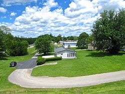 Houses in Eubank | |
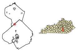 Location of Eubank in Lincoln County, Kentucky. | |
| Coordinates: 37°16′48″N 84°39′26″W / 37.28000°N 84.65722°WCoordinates: 37°16′48″N 84°39′26″W / 37.28000°N 84.65722°W | |
| Country | United States |
| State | Kentucky |
| Counties | Pulaski, Lincoln |
| Government | |
| • Mayor | Frey Todd |
| Area | |
| • Total | 0.9 sq mi (2 km2) |
| • Land | 0.9 sq mi (2 km2) |
| • Water | 0.0 sq mi (0 km2) |
| Elevation | 1,204 ft (367 m) |
| Population (2010) | |
| • Total | 319 |
| • Estimate (2016)[1] | 325 |
| • Density | 395.2/sq mi (152.6/km2) |
| Time zone | UTC-5 (Eastern (EST)) |
| • Summer (DST) | UTC-4 (EDT) |
| ZIP code | 42567 |
| Area code(s) | 606 |
| FIPS code | 21-25552 |
| GNIS feature ID | 0491823 |
Eubank is a home rule-class city in Lincoln and Pulaski counties in the U.S. state of Kentucky. The population was 319 at the 2010 census.
The Pulaski County portion of Eubank is part of the Somerset Micropolitan Statistical Area, while the Lincoln County portion is part of the Danville Micropolitan Statistical Area. Eubank is the current home of former Detroit Tigers outfielder Josh Anderson and Miss America 1944 Venus Ramey.
History
The town was named for landowner Wesley Eubank and was a stop on the Cincinnati Southern Railroad.[2] It was incorporated by the state assembly in 1886 and is also known as Eubanks.[3]
Geography
Eubank is located at 37°16′48″N 84°39′26″W / 37.28000°N 84.65722°W (37.279992, -84.657100).[4] The city is concentrated around the intersection of Kentucky Route 1247 and Kentucky Route 70. U.S. Route 27 passes along the city's eastern border. Most of Eubank is located in Pulaski County, with only a small portion extending into Lincoln County.
According to the United States Census Bureau, the city has a total area of 0.9 square miles (2.3 km2), all land.

Demographics
| Historical population | |||
|---|---|---|---|
| Census | Pop. | %± | |
| 1910 | 182 | — | |
| 1920 | 312 | 71.4% | |
| 1930 | 334 | 7.1% | |
| 1940 | 303 | −9.3% | |
| 1950 | 322 | 6.3% | |
| 1960 | 303 | −5.9% | |
| 1970 | 230 | −24.1% | |
| 1980 | 207 | −10.0% | |
| 1990 | 354 | 71.0% | |
| 2000 | 358 | 1.1% | |
| 2010 | 319 | −10.9% | |
| Est. 2016 | 325 | [1] | 1.9% |
| U.S. Decennial Census[5] | |||
As of the census[6] of 2000, there were 358 people, 141 households, and 102 families residing in the city. The population density was 395.2 per square mile (152.6/km2). There were 173 housing units at an average density of 191.0 per square mile (73.7/km2). The racial makeup of the city was 97.77% White, 1.68% Native American, and 0.56% from two or more races.
There were 141 households out of which 31.2% had children under the age of 18 living with them, 55.3% were married couples living together, 14.9% had a female householder with no husband present, and 27.0% were non-families. 27.0% of all households were made up of individuals and 14.2% had someone living alone who was 65 years of age or older. The average household size was 2.54 and the average family size was 3.06.
The age distribution was 26.3% under the age of 18, 8.9% from 18 to 24, 29.3% from 25 to 44, 20.9% from 45 to 64, and 14.5% who were 65 years of age or older. The median age was 35 years. For every 100 females, there were 87.4 males. For every 100 females age 18 and over, there were 82.1 males.
The median income for a household in the city was $18,409, and the median income for a family was $19,625. Males had a median income of $26,944 versus $16,667 for females. The per capita income for the city was $15,599. About 22.4% of families and 32.2% of the population were below the poverty line, including 52.9% of those under age 18 and 17.5% of those age 65 or over.
References
- 1 2 "Population and Housing Unit Estimates". Retrieved June 9, 2017.
- ↑ Rennick, Robert M. (1987). Kentucky Place Names. University Press of Kentucky. p. 95. Retrieved 2013-04-28.
- ↑ Commonwealth of Kentucky. Office of the Secretary of State. Land Office. "Eubank, Kentucky". Accessed 25 July 2013.
- ↑ "US Gazetteer files: 2010, 2000, and 1990". United States Census Bureau. 2011-02-12. Retrieved 2011-04-23.
- ↑ "Census of Population and Housing". Census.gov. Archived from the original on May 12, 2015. Retrieved June 4, 2015.
- ↑ "American FactFinder". United States Census Bureau. Archived from the original on September 11, 2013. Retrieved 2008-01-31.
External links

Municipalities and communities of Lincoln County, Kentucky, United States | ||
|---|---|---|
| Cities |  | |
| Unincorporated communities | ||
| Footnotes | ‡This populated place also has portions in an adjacent county | |
Municipalities and communities of Pulaski County, Kentucky, United States | ||
|---|---|---|
| Cities |  | |
| Unincorporated communities | ||
| Ghost towns | ||
| Footnotes | ‡This populated place also has portions in an adjacent county | |