Etna, Utah
| Etna, Utah | |
|---|---|
| Unincorporated community | |
 Etna Location within the state of Utah | |
| Coordinates: 41°40′18″N 113°57′16″W / 41.67167°N 113.95444°WCoordinates: 41°40′18″N 113°57′16″W / 41.67167°N 113.95444°W | |
| Country | United States |
| State | Utah |
| County | Box Elder |
| Elevation | 5,223 ft (1,592 m) |
| Time zone | UTC-7 (Mountain (MST)) |
| • Summer (DST) | UTC-6 (MDT) |
| GNIS feature ID | 1437556[1] |
Etna is an unincorporated community located in western Box Elder County, Utah, United States, five miles southwest of Grouse Creek. It lies at an elevation of 5,223 feet (1,592 m).[1][2][3]
Originally called West Fork, Etna was settled in 1875 by Valison and Alma C. Tanner. The permanent name of Etna was later chosen by a local mail carrier.
See also
![]()
References
- 1 2 "Etna". Geographic Names Information System. United States Geological Survey.
- ↑ MyTopo Maps - Etna, UT, United States (Map). Trimble Navigation, Ltd. Retrieved 30 Jul 2017.
- ↑ Google (30 Jul 2017). "Etna, Utah 84313" (Map). Google Maps. Google. Retrieved 30 Jul 2017.
External links
![]()
Municipalities and communities of Box Elder County, Utah, United States | ||
|---|---|---|
| Cities | 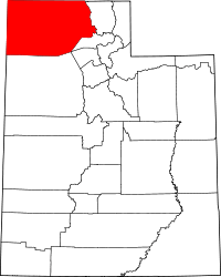 | |
| Towns | ||
| CDPs | ||
| Unincorporated areas | ||
| Ghost towns | ||
| Indian reservation | ||
This article is issued from
Wikipedia.
The text is licensed under Creative Commons - Attribution - Sharealike.
Additional terms may apply for the media files.