Etna, Minnesota
| Etna, Minnesota | |
|---|---|
| Unincorporated community | |
 Etna  Etna | |
| Coordinates: 43°36′08″N 92°20′49″W / 43.60222°N 92.34694°WCoordinates: 43°36′08″N 92°20′49″W / 43.60222°N 92.34694°W | |
| Country | United States |
| State | Minnesota |
| County | Fillmore |
| Township | Bloomfield Township |
| Elevation | 1,283 ft (391 m) |
| Time zone | UTC-6 (Central (CST)) |
| • Summer (DST) | UTC-5 (CDT) |
| ZIP codes | 55975 |
| Area code(s) | 507 |
| GNIS feature ID | 654698[1] |
Etna is an unincorporated community in Bloomfield Township, Fillmore County, Minnesota, United States. Etna is located within ZIP code 55975 based in Spring Valley.
History
A post office previously operated in the community of Etna from 1856 to 1901.[2] The community was named for Mount Etna, on Sicily.[3]
Geography
The community is located 8 miles southeast of Spring Valley, at the junction of Fillmore County 14 and 153rd Avenue. U.S. Highway 63 is nearby.
Etna Creek and the South Branch Root River both flow through the community.
Nearby places in Minnesota include Spring Valley, Ostrander, Le Roy, Cherry Grove, and Greenleafton. Nearby places in Iowa include Chester and Lime Springs.
Etna is located 5 miles east of Ostrander; and 4 miles west of Cherry Grove. Forestville Mystery Cave State Park is also nearby.
References
- ↑ "Etna, Minnesota". Geographic Names Information System. United States Geological Survey.
- ↑ "Fillmore County". Jim Forte Postal History. Retrieved 30 May 2015.
- ↑ Upham, Warren (1920). Minnesota Geographic Names: Their Origin and Historic Significance. Minnesota Historical Society. p. 192.
- Official State of Minnesota Highway Map – 2011/2012 edition
Municipalities and communities of Fillmore County, Minnesota, United States | ||
|---|---|---|
| Cities | 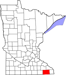 | |
| Townships | ||
| Unincorporated communities | ||
| Ghost town | ||
| Footnotes | ‡This populated place also has portions in an adjacent county or counties | |