Ethridge, Montana
| Ethridge, Montana | |
|---|---|
| Unincorporated community | |
 Ethridge, Montana  Ethridge, Montana | |
| Coordinates: 48°33′28″N 112°07′14″W / 48.55778°N 112.12056°WCoordinates: 48°33′28″N 112°07′14″W / 48.55778°N 112.12056°W | |
| Country | United States |
| State | Montana |
| County | Toole |
| Elevation | 3,543 ft (1,080 m) |
| Time zone | UTC-7 (Mountain (MST)) |
| • Summer (DST) | UTC-6 (MDT) |
| ZIP code | 59435 |
| Area code(s) | 406 |
| GNIS feature ID | 771247[1] |
Ethridge is an unincorporated community in Toole County, Montana, United States. It is located 12.6 miles (20.3 km) east-northeast of Shelby. It is positioned along U.S. Route 2 and is part of the Hi-Line. The community has a post office with ZIP code 59435.[2][3]
References
- ↑ "Ethridge". Geographic Names Information System. United States Geological Survey.
- ↑ United States Postal Service (2012). "USPS - Look Up a ZIP Code". Retrieved 2012-02-15.
- ↑ "Postmaster Finder - Post Offices by ZIP Code". United States Postal Service. Retrieved July 8, 2014.
Municipalities and communities of Toole County, Montana, United States | ||
|---|---|---|
| City | 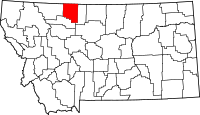 | |
| Towns | ||
| CDP | ||
| Unincorporated communities | ||
This article is issued from
Wikipedia.
The text is licensed under Creative Commons - Attribution - Sharealike.
Additional terms may apply for the media files.