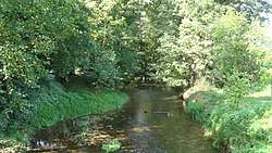
Espolde
| Espolde | |
|---|---|
 | |
| Country | Germany |
| Location | Lower Saxony |
| Physical characteristics | |
| River mouth |
Leine 51°37′36″N 9°55′35″E / 51.6266°N 9.9263°ECoordinates: 51°37′36″N 9°55′35″E / 51.6266°N 9.9263°E |
| Length | 16.1 km (10.0 mi) [1] |
| Basin features | |
| Progression | Leine→ Aller→ Weser→ North Sea |
Espolde is a river of Lower Saxony, Germany. It flows into the Leine near Nörten-Hardenberg.
Location
The Espolde originates in the eastern foothills of the low mountain range Solling. Its source is located just north of the village Espol at about 311 m above sea level. NN.
At the beginning of Espolde, following the descent of the Solling, south-east-easterly direction between the Solling in the west and the Wee-Wee in the east, through Üssinghausen and Trögen (both to Hardegsen) flowing along the southeast edge of Solling-Vogler Nature Park. It is aimed at the core city of Hardegsen, which has been reached after crossing the Sollingbahn, where it changes its flow direction to the east southeast. From here, the river runs parallel to Bundesstraße 241, which crosses it, and then to Bundesstraße 446. It passes through Hevensen (to Hardegsen) and Wolbrechtshausen (to Nörten-Hardenberg) and crosses the federal highway 7 below Lütgenrode (to Nörten-Hardenberg).
The Espolde enters the trench of the dugout in order to reach a height of about 126 m above sea level. NN into the lead; Opposite its mouth - beyond the Leine and Bundesstraße 3 - Marienstein (to Nörten-Hardenberg).
See also
References