Esgeiriau Gwynion
| Esgeiriau Gwynion | |
|---|---|
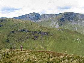 Aran Fawddwy and Foel Hafod-fynydd (left) from the summit | |
| Highest point | |
| Elevation | 671 m (2,201 ft) |
| Prominence | 166 m (545 ft) |
| Parent peak | Aran Fawddwy |
| Listing | Marilyn, Hewitt, Nuttall |
| Naming | |
| Translation | White Ridges (Welsh) |
| Geography | |
| Location | Gwynedd, Wales |
| Parent range | Aran Fawddwy |
| Topo map | OS Landranger 125 |
| Listed summits of Esgeiriau Gwynion | ||||
| Name | Grid ref | Height | Status | |
|---|---|---|---|---|
| Foel Rhudd | 659 metres (2,162 ft) | Nuttall | ||
| Foel y Geifr | 626 metres (2,054 ft) | Hewitt, Nuttall | ||
| Moel y Cerrig Duon | 625 metres (2,051 ft) | Hewitt, Nuttall | ||
| Llechwedd Du | 614 metres (2,014 ft) | Hewitt, Nuttall | ||
| Foel Goch (Hirnant) | 613 metres (2,011 ft) | Hewitt, Nuttall | ||
| Cefn Coch | 606 m (1,988 ft) | sub Hewitt | ||
Esgeiriau Gwynion is a mountain in north east Wales. It is the smallest of the three Marilyns that form the Aran range, the others being Aran Fawddwy and Glasgwm.
The peak is situated to the east of Aran Fawddwy, separated by Bwlch Sirddyn, and stretches right the way round Cwn Cynllwyd towards the Berwyn range at Foel y Geifr. The tops are all boggy in character, all rising from a wild, peat bog plateau. A road penetrates the plateau at Bwlch y Groes.[1]
References
External links
Coordinates: 52°47′56″N 3°38′55″W / 52.798943°N 3.648549°W
This article is issued from
Wikipedia.
The text is licensed under Creative Commons - Attribution - Sharealike.
Additional terms may apply for the media files.