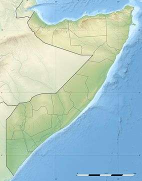
Erigavo
| Erigavo Ceerigaabo عيرجابو | |
|---|---|
| City | |
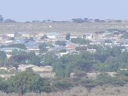 Overview of Erigavo | |
 Erigavo Somalia | |
| Coordinates: 10°37′05″N 047°22′12″E / 10.61806°N 47.37000°ECoordinates: 10°37′05″N 047°22′12″E / 10.61806°N 47.37000°E | |
| Country |
|
| Region | Sanaag |
| District | Erigavo |
| Population | |
| • Total | 114,846 |
| Time zone | UTC+3 (EAT) |
Erigavo (Somali: Ceerigaabo), also spelled as Erigabo, is the capital and largest city of the Northeastern Sanaag region of Somalia.[1]
History
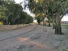
The Erigavo settlement is several centuries old. The surrounding area and the city was reported to be built by the Madigan Dir.[2] It lies approximately 180 km from Badhan, the third biggest city in the region to the east. The general area is noted for its numerous historical tombs, where various Somali clan patriarchs are buried.[3] As of 2013, Erigavo is the administrative capital of the northern Sanaag region. It is also the center of the Erigavo District. Erigavo was a city on an Isaaq trade route during the Middle Ages.
It's also where Musse Ismaeel sub-clan of Habar Yoonis is buried.
Geography
Environment
10 km (6 m) to the north of the town are the remains of a juniper forest,[4] running along the edge of the escarpment overlooking the Gulf of Aden. The escarpment is approximately 2,000 m (6,562 ft) above sea level, where the road from Erigavo drops down to the coast. 2 km (1.2 mi) to the west, it rises to the highest point in Somaliland, Shimbiris. A popular local attraction, the summit sits at an elevation of about 2670 m above sea level. A road also leads up from Erigavo to Mountain Daallo. At the mountain's peak, the sea can be observed in addition to the ancient town of Hiis situated nearby.
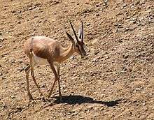
Erigavo is also home to animal and plant species. Wildlife endemic to the area include the black-backed jackal, Dorcas gazelle, hamadryas baboon, Suidae, common dwarf mongoose, Abdim's stork, long-crested eagle and hartebeest.
.
Climate
Under the Köppen climate classification, Erigavo features a mild version of the semi-arid climate. The city generally sees equable temperatures year round, with some of the mildest weather in all of Somaliland. Despite its location in the tropics, due to the high altitude, temperatures rarely exceed 30 degrees Celsius. Nights are frequently chilly, even during the summer season. This is a trait shared with very few places in the world; notable locations with similar climate are Sana'a in Yemen or Arequipa in Peru. The city receives on average under 400 mm of precipitation annually. Average monthly temperatures range from 14.3 C in the month of December to 19.7 C in the month of July. Absolute minimum temperatures sometimes touch or cross zero degrees Celsius isotherm.
| Climate data for Erigavo | |||||||||||||
|---|---|---|---|---|---|---|---|---|---|---|---|---|---|
| Month | Jan | Feb | Mar | Apr | May | Jun | Jul | Aug | Sep | Oct | Nov | Dec | Year |
| Record high °C (°F) | 30.5 (86.9) |
33.5 (92.3) |
32.0 (89.6) |
33.5 (92.3) |
31.5 (88.7) |
30.5 (86.9) |
30.5 (86.9) |
30.0 (86) |
30.0 (86) |
29.5 (85.1) |
29.5 (85.1) |
28.0 (82.4) |
33.5 (92.3) |
| Average high °C (°F) | 24.5 (76.1) |
25.5 (77.9) |
25.5 (77.9) |
26.5 (79.7) |
26.5 (79.7) |
26.0 (78.8) |
26.0 (78.8) |
26.0 (78.8) |
25.5 (77.9) |
25.0 (77) |
24.0 (75.2) |
23.5 (74.3) |
25.5 (77.9) |
| Daily mean °C (°F) | 15.0 (59) |
16.0 (60.8) |
17.0 (62.6) |
18.0 (64.4) |
19.0 (66.2) |
19.5 (67.1) |
19.5 (67.1) |
19.5 (67.1) |
18.5 (65.3) |
16.5 (61.7) |
15.5 (59.9) |
14.5 (58.1) |
17.5 (63.5) |
| Average low °C (°F) | 5.5 (41.9) |
7.0 (44.6) |
8.5 (47.3) |
10.0 (50) |
11.5 (52.7) |
13.0 (55.4) |
13.5 (56.3) |
13.5 (56.3) |
11.5 (52.7) |
8.5 (47.3) |
7.0 (44.6) |
5.5 (41.9) |
9.5 (49.1) |
| Record low °C (°F) | −3.5 (25.7) |
0.5 (32.9) |
0.5 (32.9) |
2.0 (35.6) |
1.5 (34.7) |
4.0 (39.2) |
5.0 (41) |
4.5 (40.1) |
3.0 (37.4) |
0.0 (32) |
−3.0 (26.6) |
−3.5 (25.7) |
−3.5 (25.7) |
| Average precipitation mm (inches) | 18 (0.71) |
13 (0.51) |
33 (1.3) |
38 (1.5) |
81 (3.19) |
64 (2.52) |
10 (0.39) |
41 (1.61) |
114 (4.49) |
8 (0.31) |
13 (0.51) |
2 (0.08) |
435 (17.13) |
| Average precipitation days (≥ 1.0 mm) | 1 | 3 | 6 | 5 | 8 | 9 | 1 | 5 | 15 | 1 | 2 | 0 | 56 |
| Average relative humidity (%) (at 14:00) | 34 | 35 | 42 | 56 | 51 | 48 | 43 | 49 | 55 | 43 | 34 | 37 | 44 |
| Source: Deutscher Wetterdienst[5] | |||||||||||||
Demographics
The total population of Erigavo (Ceerigaabo) city is 114,846 residents.[6] The city is primarily inhabited by people from the Somali ethnic group. It is wholly dominated by the Habar Yoonis and Habar Jeclo sub-clans of Isaaq clan.[7] Other groups inhabiting Erigavo include segments of the Warsangeli and Dhulbahante subdivisions of the Harti Darod.[8] Additionally there are several minority clans in the area such as Magaadle, Gahayle, Jibraahil and Ugayslabe.[9]
Education
Higher learning in Erigavo is provided by East Africa University (EAU), which has one of its six branches in the city.[10] The Sanaag University also offers tertiary courses and degrees.And Gollis university has a branch.And also many colleges. Queen of Sheba University offers women in Sanaag free degree courses and a limited number of places worldwide in distance mode.
Administration
Town affairs are managed by the mayor of Erigavo, as appointed by Somaliland. Taxes are levied and collected by the local town council as of 1999.[11]
Services
As of 2009, Erigavo has two hospitals serving residents, with another being constructed. The Erigavo Airport also lies to the east of the town. Additionally, the city is the seat of a few local non-governmental organizations (NGOs).
Erigavo has a modern telephone system, with widespread access to landline and mobile services. The main mobile communication services in the city are operated by the Puntland-based Golis Telecom, as well as Telcom and Telesom. STC Somaliland, another major local telecommunications company, manages electricity and telephone landlines only.
Additionally, the city is home to a Boy Scouts organization. Formed in 2005 by the local Sanaag administration, the Scouts partake in various activities, including a 2006 training program on governance, peace and leadership.[12]
Notable residents
- Abdullahi Qarshe - Father of Somali music.
- Jama Korshel – former Vice President of the Supreme Revolutionary Council
Notes
- ↑ Renders, Marleen (2012-01-20). Consider Somalia: State-Building with Traditional Leaders and Institutions. BRILL. ISBN 9789004222540.
- ↑ Ali, Ibrahim (1993). The History of the Somali People. p. 44.
(Erigaavo) it is where Madigan Dir built their castles, famous still. All around Daryale the splendors of the past are seen.
- ↑ A.H. Keane, Man, Past and Present, (Cambridge University Press: 1920), p.485.
- ↑ "Somali montane xeric woodlands". Terrestrial Ecoregions. World Wildlife Fund.
- ↑ "Klimatafel von Erigavo / Somalia" (PDF). Baseline climate means (1961-1990) from stations all over the world (in German). Deutscher Wetterdienst. Retrieved 4 November 2016.
- ↑ https://docs.unocha.org/sites/dms/Somalia/UNDP-POP-RURAL-URBAN%202005.pdf
- ↑ Refugees, United Nations High Commissioner for. "Refworld | Report on the Fact-finding Mission to Somalia and Kenya (27 October - 7 November 1997)". Refworld. Retrieved 2017-05-20.
- ↑ "District Conflict and Security Assessment Report" (PDF) (Assessement). 2015: 8. Retrieved 14 November 2017.
- ↑ Royal African Society, African affairs, Volume 101, Issues 402-405, (Oxford University Press: 2002), p.103.
- ↑ "A programme for improving governance, leadership and management capacity of the three health authorities in Somalia". Mannion Daniels Limited. Retrieved 20 June 2013.
- ↑ Renders, Marleen (2012-01-20). Consider Somaliland: State-Building with Traditional Leaders and Institutions. BRILL. ISBN 9789004222540.
- ↑ Erigavos Students Trained In Leadership
References
| Wikimedia Commons has media related to Erigavo. |