Erbé
| Erbé | |
|---|---|
| Comune | |
| Comune di Erbé | |
 Erbé Location of Erbé in Italy | |
| Coordinates: 45°15′N 10°58′E / 45.250°N 10.967°ECoordinates: 45°15′N 10°58′E / 45.250°N 10.967°E | |
| Country | Italy |
| Region | Veneto |
| Province | Province of Verona (VR) |
| Area | |
| • Total | 15.9 km2 (6.1 sq mi) |
| Elevation | 22 m (72 ft) |
| Population (Dec. 2004) | |
| • Total | 1,619 |
| • Density | 100/km2 (260/sq mi) |
| Demonym(s) | Erbetani |
| Time zone | UTC+1 (CET) |
| • Summer (DST) | UTC+2 (CEST) |
| Postal code | 37060 |
| Dialing code | 045 |
Erbé is a comune (municipality) in the Province of Verona in the Italian region Veneto, located about 110 kilometres (68 mi) west of Venice and about 20 kilometres (12 mi) south of Verona. As of December 2008, it had a population of 1,720 and an area of 15.9 square kilometres (6.1 sq mi).[1][2]
Erbé borders the following municipalities: Castelbelforte, Isola della Scala, Nogara, Sorgà, and Trevenzuolo.
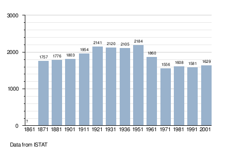
Demographic evolution
References

This article is issued from
Wikipedia.
The text is licensed under Creative Commons - Attribution - Sharealike.
Additional terms may apply for the media files.