Emporio, Kozani
| Emporio Εμπόριο | |
|---|---|
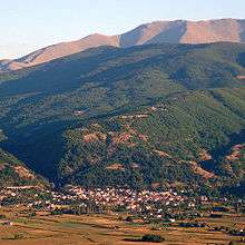 A view of Emporio | |
 Emporio | |
| Coordinates: 40°29.3′N 21°33.45′E / 40.4883°N 21.55750°ECoordinates: 40°29.3′N 21°33.45′E / 40.4883°N 21.55750°E | |
| Country | Greece |
| Administrative region | West Macedonia |
| Regional unit | Kozani |
| Municipality | Eordaia |
| Municipal unit | Mouriki |
| Highest elevation | 720 m (2,360 ft) |
| Lowest elevation | 670 m (2,200 ft) |
| Community[1] | |
| • Population | 804 (2011) |
| Time zone | UTC+2 (EET) |
| • Summer (DST) | UTC+3 (EEST) |
| Postal code | 500 05 |
| Area code(s) | +30-2463-xxx-xxx |
| Vehicle registration | ΚΖ |
Emporio (Greek: Εμπόριο) is a village and a community of the Eordaia municipality.[2] Before the 2011 local government reform it was part of the municipality of Mouriki, of which it was a municipal district and the seat.[2] The 2011 census recorded 804 inhabitants in the village.[1]
History
According to Ottoman document from 1626 to 1627, there were 71 Christian households in the village in the first half of the 17th century.[3]
Notable natives
- Kroum Pindoff, Bulgarian-Canadian businessman
References
- 1 2 "Απογραφή Πληθυσμού - Κατοικιών 2011. ΜΟΝΙΜΟΣ Πληθυσμός" (in Greek). Hellenic Statistical Authority.
- 1 2 Kallikratis law Greece Ministry of Interior (in Greek)
- ↑ Турски извори за българската история, т. VII, София 1986, с. 333
This article is issued from
Wikipedia.
The text is licensed under Creative Commons - Attribution - Sharealike.
Additional terms may apply for the media files.