Emmerthal
| Emmerthal | ||
|---|---|---|
| ||
 Emmerthal Location of Emmerthal within Hameln-Pyrmont district 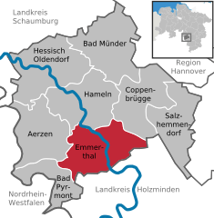  | ||
| Coordinates: 52°3′N 9°23′E / 52.050°N 9.383°ECoordinates: 52°3′N 9°23′E / 52.050°N 9.383°E | ||
| Country | Germany | |
| State | Lower Saxony | |
| District | Hameln-Pyrmont | |
| Government | ||
| • Mayor | Andreas Grossmann | |
| Area | ||
| • Total | 115 km2 (44 sq mi) | |
| Elevation | 69 m (226 ft) | |
| Population (2017-12-31)[1] | ||
| • Total | 9,847 | |
| • Density | 86/km2 (220/sq mi) | |
| Time zone | CET/CEST (UTC+1/+2) | |
| Postal codes | 31860 | |
| Dialling codes | 05155, 05157, 05286, 05151 | |
| Vehicle registration | HM | |
| Website | www.emmerthal.de | |

Emmerthal is a municipality in the Hameln-Pyrmont district, in Lower Saxony, Germany. It is situated on the river Weser, approximatively 6 km south of Hameln. Its seat is in the village Kirchohsen.
In 1973, the Emmerthal was formed by merging the previously independent municipalities of Amelgatzen, Bessinghausen, Börry, Brockensen, Emmern, Esperde, Frenke, Grohnde, Hagenohsen, Hajen, Hämelschenburg, Kirchohsen, Latferde, Lüntorf, Ohr, Voremberg, Welsede.
The Grohnde Nuclear Power Plant is located in the Emmerthal.
From 1933-1937, a field on the nearby hill of the Bückeberg was the place where the national socialists celebrated the national thanksgiving festival.
References
Towns and municipalities in Hamelin-Pyrmont (district) | ||
|---|---|---|
| Authority control |
|---|
This article is issued from
Wikipedia.
The text is licensed under Creative Commons - Attribution - Sharealike.
Additional terms may apply for the media files.