Emerald Grove, Wisconsin
| Emerald Grove, Wisconsin | |
|---|---|
| Unincorporated community | |
 Looking east along U.S. Route 14 in Emerald Grove | |
 Emerald Grove, Wisconsin  Emerald Grove, Wisconsin | |
| Coordinates: 42°39′22″N 88°52′50″W / 42.65611°N 88.88056°WCoordinates: 42°39′22″N 88°52′50″W / 42.65611°N 88.88056°W | |
| Country | United States |
| State | Wisconsin |
| County | Rock |
| Elevation | 899 ft (274 m) |
| Time zone | UTC-6 (Central (CST)) |
| • Summer (DST) | UTC-5 (CDT) |
| Area code(s) | 608 |
| GNIS feature ID | 1564611[1] |
Emerald Grove is an unincorporated community in the Town of Bradford, in Rock County, Wisconsin, United States. It is located along U.S. Route 14 and Wisconsin Highway 11 east of Janesville and west of Delavan.
Notable people
- G. F. A. Atherton, member of the Wisconsin State Assembly in the 1st Wisconsin Legislature in 1848, and later a railroad director
- Andrew Barlass, member of the Wisconsin State Assembly (1874–76)
- William Gardiner, member of the Wisconsin State Assembly (1879)
- Robert More, member of the Wisconsin State Assembly (1899-1900)
- Thomas Westby, member of the Wisconsin State Assembly (1860)
References
Municipalities and communities of Rock County, Wisconsin, United States | ||
|---|---|---|
| Cities | 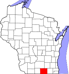 | |
| Villages | ||
| Towns | ||
| CDP | ||
| Unincorporated communities |
| |
| Ghost towns/neighborhoods | ||
| Footnotes | ‡This populated place also has portions in an adjacent county or counties | |
This article is issued from
Wikipedia.
The text is licensed under Creative Commons - Attribution - Sharealike.
Additional terms may apply for the media files.