Embarcadero (San Diego)
The Embarcadero in San Diego, California is the area along the San Diego harbor on the east side of San Diego Bay. "Embarcadero" is a Spanish word meaning "landing place". The Embarcadero sits on property administered by the Port of San Diego, in the Columbia district of Downtown San Diego.
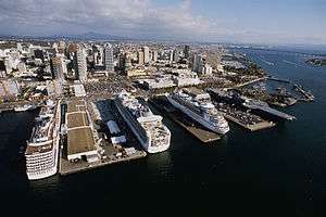
The Embarcadero is home to the San Diego cruise ship terminal, the USS Midway museum ship at Navy Pier, the Star of India and seven other historic vessels belonging to the San Diego Maritime Museum, and various restaurants and shops from the North Embarcadero down through Seaport Village. The Port is redeveloping the historic Broadway Pier to create a second cruise-ship pier and terminal. That project is slated for completion in December 2010.
Embarcadero Circle
Embarcadero Circle is a redevelopment project in the North Embarcadero, located at Broadway and Harbor Drive. It is scheduled for completion in 2010. It will include the new cruise ship terminal at Broadway Pier, as well as two hotels: a 27-story Marriott hotel with 500 rooms and a 20,000 sq ft (1,900 m2). concert venue, and a 40 story Manchester Grand Hyatt [1] Embarcadero Circle is located north of the Navy Broadway Complex.[2]
North Embarcadero Visionary Plan
In 1997[3] a major redevelopment of the Embarcadero was proposed, to be carried out through a Joint Powers Authority (JPA), composed of the City of San Diego, the Centre City Development Corporation (CCDC), and the Port of San Diego. The proposed redevelopment was called the North Embarcadero Visionary Plan, a multi-phased redevelopment of the waterfront in Downtown San Diego. This redevelopment project proposed to move Harbor Drive 40 feet (12 m) to the east and build an esplanade from B Street Pier to the former Navy Pier along Harbor Drive. It also included public art displays, tree groves and open spaces, while continuing San Diego's tradition of having a working waterfront, according to Port plans.[4] The proposed redevelopment area was bordered by Market Street to the south (Marina District), Laurel Street to the north (Little Italy), and the railroad tracks to the east.
However, the proposed redevelopment project was sent back to the drawing boards in April 2010 when the California Coastal Commission rejected it. A major issue was the disappearance from the plan of an originally proposed 79,000-square-foot (7,300 m2) grassy park. In the plan rejected by the Coastal Commission, the park had been replaced by a smaller, hardscape plaza.[5] The Port will now amend its master plan and resubmit its proposal for Coastal Commission approval - a process that can take several years.
References
- ↑ "Unknown Article". Sandiego.org. Retrieved 2011-07-01.
- ↑ Freeman, Mike (2006-03-08). "Not quite smooth sailing | The San Diego Union-Tribune". Signonsandiego.com. Retrieved 2011-07-01.
- ↑ "Centre City Development Corporation". Ccdc.com. Archived from the original on 2011-07-06. Retrieved 2011-07-01.
- ↑ North Embarcadero Visionary Plan at portofsandiego.org
- ↑ "The Log newspaper, April 28, 2010". Thelog.com. Archived from the original on 2011-07-17. Retrieved 2011-07-01.
Coordinates: 32°42′54″N 117°10′31″W / 32.71500°N 117.17528°W