Elterlein
| Elterlein | ||
|---|---|---|
| ||
 Elterlein Location of Elterlein within Erzgebirgskreis district 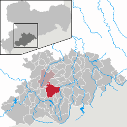 | ||
| Coordinates: 50°34′37″N 12°52′2″E / 50.57694°N 12.86722°ECoordinates: 50°34′37″N 12°52′2″E / 50.57694°N 12.86722°E | ||
| Country | Germany | |
| State | Saxony | |
| District | Erzgebirgskreis | |
| Municipal assoc. | Geyer | |
| Government | ||
| • Mayor | Karl Weinhold (CDU) | |
| Area | ||
| • Total | 45.87 km2 (17.71 sq mi) | |
| Elevation | 620 m (2,030 ft) | |
| Population (2017-12-31)[1] | ||
| • Total | 2,854 | |
| • Density | 62/km2 (160/sq mi) | |
| Time zone | CET/CEST (UTC+1/+2) | |
| Postal codes | 09481 | |
| Dialling codes | 037349 | |
| Vehicle registration | ERZ | |
| Website | www.elterlein-stadt.de | |

Elterlein is a town in the district of Erzgebirgskreis, in the Free State of Saxony, Germany. It is situated in the Ore Mountains, 10 km west of Annaberg-Buchholz.
Notable people
- Wolfgang Uhle (1512-1594), known as the plague priest of Annaberg
- Karl Weinhold (born 1946), politician (CDU), Member of Landtag, mayor of Elterlein (1990-2009)
- Christian Gotthold Hoffmann (1713-1784), scientist
References
- ↑ "Aktuelle Einwohnerzahlen nach Gemeinden 2017] (Einwohnerzahlen auf Grundlage des Zensus 2011)" (PDF). Statistisches Landesamt des Freistaates Sachsen (in German). October 2018.
This article is issued from
Wikipedia.
The text is licensed under Creative Commons - Attribution - Sharealike.
Additional terms may apply for the media files.