Elstronwick
| Elstronwick | |
|---|---|
 Elstronwick Elstronwick shown within the East Riding of Yorkshire | |
| Population | 298 (2011 census)[1] |
| OS grid reference | TA230321 |
| • London | 155 mi (249 km) S |
| Civil parish |
|
| Unitary authority | |
| Ceremonial county | |
| Region | |
| Country | England |
| Sovereign state | United Kingdom |
| Post town | HULL |
| Postcode district | HU12 |
| Dialling code | 01964 |
| Police | Humberside |
| Fire | Humberside |
| Ambulance | Yorkshire |
| EU Parliament | Yorkshire and the Humber |
| UK Parliament | |
Elstronwick is a village and civil parish in the East Riding of Yorkshire, England, in an area known as Holderness. It is situated approximately 3.5 miles (6 km) north-east of the town of Hedon and 1.5 miles (2.4 km) north-west of the village of Burton Pidsea.
The civil parish is formed by the villages of Elstronwick and Lelley together with the hamlet of Danthorpe. According to the 2011 UK census, Elstronwick parish had a population of 298,[1] an increase on the 2001 UK census figure of 287.[2]
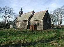
The parish church of St Lawrence on Front Lane is designated a Grade II listed building and is now recorded in the National Heritage List for England, maintained by Historic England.[3] There is also a chapel. A further Grade II listed building is Elstronwick Hall.[4]
Village amenities include a public house and a small playing field.
In 1823 Baines's History, Directory and Gazetteer of the County of York gave Elstronwick's name as 'Elsternwick'. The village at the time was in the parish of Humbleton and in the Wapentake of Holderness. There was a chapel of ease, "apparently of great antiquity", and a free school. The village had a population of 154, with occupations including six farmers, two wheelwrights, a blacksmith, a shoemaker, and the licensed victualler of The Crown & Anchor public house. Also directory-listed was a school mistress, two gentlemen and a foreman. Once a week a carrier operated between the village and Hull.[5]
References
- 1 2 UK Census (2011). "Local Area Report – Elstronwick Parish (1170211175)". Nomis. Office for National Statistics. Retrieved 17 February 2018.
- ↑ "2001 Census: Key Statistics: Parish Headcounts: Area: Elstronwick CP (Parish)". Neighbourhood Statistics. Office for National Statistics. Retrieved 15 May 2008.
- ↑ Historic England. "Church of St Lawrence (1287848)". National Heritage List for England. Retrieved 29 April 2013.
- ↑ Historic England. "Elstronwick Hall (1346613)". National Heritage List for England. Retrieved 7 July 2014.
- ↑ Baines, Edward (1823). History, Directory and Gazetteer of the County of York. p. 201.
- Gazetteer — A–Z of Towns Villages and Hamlets. East Riding of Yorkshire Council. 2006. p. 5.
External links

- Elstronwick in the Domesday Book