Elsburg
| Elsburg | |
|---|---|
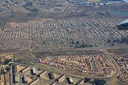 Aerial view overhead Elsburg | |
 Elsburg  Elsburg Elsburg (South Africa)  Elsburg Elsburg (Africa) | |
| Coordinates: 26°14′42″S 28°11′49″E / 26.245°S 28.197°ECoordinates: 26°14′42″S 28°11′49″E / 26.245°S 28.197°E | |
| Country | South Africa |
| Province | Gauteng |
| Municipality | Ekurhuleni |
| Main Place | Germiston |
| Area[1] | |
| • Total | 3.05 km2 (1.18 sq mi) |
| Population (2011)[1] | |
| • Total | 6,231 |
| • Density | 2,000/km2 (5,300/sq mi) |
| Racial makeup (2011)[1] | |
| • Black African | 22.3% |
| • Coloured | 3.8% |
| • Indian/Asian | 2.7% |
| • White | 70.7% |
| • Other | 0.5% |
| First languages (2011)[1] | |
| • Afrikaans | 65.0% |
| • English | 16.2% |
| • Zulu | 4.6% |
| • Sotho | 2.2% |
| • Other | 12.1% |
| Time zone | UTC+2 (SAST) |
| Postal code (street) | 1428 |
| PO box | 1407 |
Elsburg is a town in Ekurhuleni in the Gauteng province of South Africa. It is a town some 6 km south-east of Germiston.
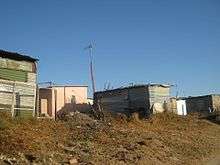
A squatter camp on the outskirts of Elsburg.
History
Laid out on the farm Klippoortjie in 1887 and proclaimed a town in 1908, it was named after the owner, F C Els. It was administered by a health committee from 1908 and by a village council from 1938. Municipal status was achieved in October 1957. It almost became the capital of the goldfields instead of Johannesburg.[2]
References
- 1 2 3 4 "Sub Place Elsburg". Census 2011.
- ↑ "Dictionary of Southern African Place Names (Public Domain)". Human Science Research Council. p. 154.
Communities of Ekurhuleni, Gauteng | ||
|---|---|---|
Seat: Germiston | ||
| Places in Ekurhuleni | .svg.png) | |
This article is issued from
Wikipedia.
The text is licensed under Creative Commons - Attribution - Sharealike.
Additional terms may apply for the media files.