City of Ekurhuleni Metropolitan Municipality
| Ekurhuleni | ||
|---|---|---|
| City | ||
| ||
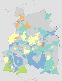
.svg.png) Location in Gauteng | ||
| Coordinates: 26°13′7″S 28°09′46″E / 26.21861°S 28.16278°ECoordinates: 26°13′7″S 28°09′46″E / 26.21861°S 28.16278°E | ||
| Country | South Africa | |
| Province | Gauteng | |
| Seat | Germiston | |
| Wards | 101 | |
| Government[1] | ||
| • Type | Municipal council | |
| • Mayor | Mzwandile Masina[2] (ANC) | |
| Area | ||
| • Total | 1,975 km2 (763 sq mi) | |
| Population (2011)[3] | ||
| • Total | 3,178,470 | |
| • Density | 1,600/km2 (4,200/sq mi) | |
| Racial makeup (2011)[3] | ||
| • Black African | 78.7% | |
| • Coloured | 2.7% | |
| • Indian/Asian | 2.1% | |
| • White | 15.8% | |
| First languages (2011)[4] | ||
| • Zulu | 28.8% | |
| • English | 12.0% | |
| • Afrikaans | 11.9% | |
| • Northern Sotho | 11.4% | |
| • Other | 35.9% | |
| Time zone | UTC+2 (SAST) | |
| Municipal code | EKU | |
| GDP | US$ 55.3 billion[5] | |
| GDP per capita | US$ 17,361[5] | |
The City of Ekurhuleni Metropolitan Municipality is a metropolitan municipality that forms the local government of the East Rand region of Gauteng, South Africa. The name Ekurhuleni means place of peace in XiTsonga. Ekurhuleni is one of the five districts of Gauteng province and one of the eight metropolitan municipalities of South Africa. The seat of Ekurhuleni is Germiston. The most common native language spoken by its 3.17 million people is IsiZulu, as of the 2001 Census. OR Tambo International Airport falls in the Kempton Park area of Ekurhuleni.[6]
History
The municipality was established in 2000, superseding the Eastern Gauteng Services Council, the Khayalami Metropolitan Council, and the previous administrations of Alberton, Benoni, Boksburg, Brakpan, Edenvale/Lethabong, Germiston, Kempton Park/Tembisa, Nigel and Springs.[7]
The planned abolition of the Lesedi Local Municipality, which includes Heidelberg, and its absorption into Ekurhuleni after the 2016 municipal elections, were blocked by the High Court of South Africa in 2015.[8]
The name Ekurhuleni meaning place of peace alludes to the fact that the East Rand townships were the site of severe political violence between supporters of the Inkatha Freedom Party and the ANC in the early 1990's, prior to South Africa's first democratic elections in 1994.[9]
Geography
Ekurhuleni lies on the plateau that is the highveld at about 1600 metres in altitude. The highest elevation is at the Gillooly's Ridge – Bill Stewart Side – Fisher's Hill at 1772m asl.[10] The lowest point is at 1552m asl. The city is rich in wetlands, pans, streams and rivers.[11] The city is highly urbanised; however, the north especially has high-potential agricultural land.[12]
Climate
Ekurhuleni has a Cwb climate according to the Köppen-Geiger Climate classification.[13] This classifies a warm temperate climate of warm summers and dry winters. In the winter months (May - October) the city has a diurnal temperature pattern with a high amplitude, as temperatures can range from freezing at night to mid 20s °C in the day.
The main precipitation falls between October and March with a monthly average precipitation of up to 148mm which falls usually in convective thundershowers.[14] The daily maximum temperatures in October-March are on average 27 °C. The Winter is mostly dry with only a few cold fronts reaching the highveld from the southern Atlantic Ocean.[15]
| Climate data for Ekurhuleni | |||||||||||||
|---|---|---|---|---|---|---|---|---|---|---|---|---|---|
| Month | Jan | Feb | Mar | Apr | May | Jun | Jul | Aug | Sep | Oct | Nov | Dec | Year |
| Record high °C (°F) | 33.8 (92.8) |
33.5 (92.3) |
35.2 (95.4) |
29.4 (84.9) |
29.2 (84.6) |
28.8 (83.8) |
24.5 (76.1) |
27.0 (80.6) |
33.0 (91.4) |
32.5 (90.5) |
33.6 (92.5) |
33.0 (91.4) |
35.2 (95.4) |
| Average high °C (°F) | 32 (90) |
32 (90) |
30 (86) |
27 (81) |
25 (77) |
22 (72) |
22 (72) |
26 (79) |
30 (86) |
32 (90) |
32 (90) |
32 (90) |
28.5 (83.3) |
| Daily mean °C (°F) | 27 (81) |
27 (81) |
26 (79) |
23 (73) |
21 (70) |
18 (64) |
18 (64) |
21 (70) |
25 (77) |
26 (79) |
27 (81) |
27 (81) |
24 (75) |
| Average low °C (°F) | 14 (57) |
13 (55) |
13 (55) |
10 (50) |
6 (43) |
2 (36) |
2 (36) |
4 (39) |
8 (46) |
11 (52) |
13 (55) |
14 (57) |
9 (48) |
| Record low °C (°F) | 6 (43) |
0 (32) |
1 (34) |
−1 (30) |
−5 (23) |
−7 (19) |
−6 (21) |
−7 (19) |
−3 (27) |
2 (36) |
1 (34) |
0 (32) |
−7 (19) |
| Average rainfall mm (inches) | 132 (5.2) |
86 (3.39) |
79 (3.11) |
41 (1.61) |
13 (0.51) |
5 (0.2) |
2 (0.08) |
7 (0.28) |
20 (0.79) |
85 (3.35) |
114 (4.49) |
142 (5.59) |
726 (28.58) |
| Average rainy days (≥ 1.0 mm) | 21 | 16.5 | 14.8 | 7.5 | 2.9 | 1.5 | 0.6 | 1.9 | 5.3 | 15.5 | 19.1 | 22.9 | 129.5 |
| Mean monthly sunshine hours | 250.1 | 224.8 | 238.8 | 236.9 | 276.0 | 266.9 | 283.9 | 284.1 | 280.8 | 269.5 | 248.7 | 263.9 | 3,124.4 |
| Source #1: meteoblue[16] | |||||||||||||
| Source #2: World Meteorological Organisation (UN)[17] | |||||||||||||
Main places
The 2001 census divided the municipality into the following main places:[18]
| Place | Code | Area (km2) | Population | Most spoken languages |
|---|---|---|---|---|
| Alberton | 77301 | 80.45 | 89,392 | Afrikaans 49%, English 38% |
| Bapsfontein | 77302 | 0.31 | 936 | Zulu 34%, Pedi 17%, Sotho 13% |
| Bedfordview | 77303 | 15.43 | 21,294 | English 71%, |
| Benoni | 77304 | 187.99 | 94,341 | English 46%, Afrikaans 24%, Zulu 12% |
| Boksburg | 77305 | 164.05 | 158,649 | Afrikaans 30%, English 22%, Zulu 15% |
| Brakpan | 77306 | 196.35 | 62,113 | Afrikaans 55%, English 15%, Zulu 13% |
| Cerutiville | 77307 | 0.41 | 2,151 | Zulu 67%, Afrikaans 12%, Sotho 12% |
| Chief Albert Lutuli Park | 77308 | 1.12 | 2,896 | Zulu 44%, Pedi 15%, Sotho 12%, Xhosa 11% |
| Daveyton | 77309 | 14.17 | 131,390 | Zulu 40%, Pedi 16%, Xhosa 12%, Sotho 11% |
| Duduza | 77310 | 10.74 | 71,960 | Zulu 63%, Sotho 19% |
| Dukathole | 77311 | 1.07 | 18,537 | Xhosa 26%, Zulu 25%, Pedi 18%, Sotho 11% |
| Edenvale | 77312 | 20.38 | 40,624 | English 74% |
| Etwatwa | 77314 | 21.26 | 124,435 | Zulu 47%, Pedi 13%, Tsonga 11% |
| Germiston | 77315 | 129.14 | 139,719 | Afrikaans 27%, English 26%, Zulu 13%, Xhosa 10% |
| Katlehong | 77316 | 61.42 | 349,866 | Zulu 39%, Sotho 25%, Xhosa 13% |
| Kempton Park | 77317 | 158.50 | 117,271 | Afrikaans 47%, English 28% |
| KwaThema | 77318 | 13.93 | 99,517 | Zulu 57% |
| Lindelani Village | 77319 | 1.60 | 7,514 | Zulu 41%, Pedi 20% |
| Nigel | 77321 | 129.29 | 28,706 | Afrikaans 51%, English 19%, Zulu 17% |
| Reiger Park | 77322 | 5.70 | 36,004 | Afrikaans 48%, Pedi 12%, Xhosa 11% |
| Springs | 77323 | 172.18 | 80,776 | Afrikaans 39%, English 21%, Zulu 14% |
| Tembisa | 77324 | 32.44 | 348,693 | Pedi 35%, Zulu 25%, Tsonga 12% |
| Thokoza | 77325 | 8.65 | 85,106 | Zulu 39%, Sotho 27%, Xhosa 20% |
| Tsakane | 77326 | 29.74 | 144,289 | Zulu 57%, Sotho 11% |
| Vosloorus | 77327 | 28.65 | 150,277 | Zulu 48%, Sotho 19% |
| Wattville | 77328 | 4.78 | 49,927 | Zulu 43%, English 16%, Sotho 10% |
| Remainder of the municipality | 77313 | 420.74 | 18,795 | Zulu 26%, Pedi 21%, Tsonga 14%, Sotho 10% |
Parks and nature
Ekurhuleni has over 206 wetlands and lakes.
Germiston Lake is a natural pan in the Elsburgspruit system and has a catchment area of 1174ha. It is fed mostly by surface runoff water and stormwater drains. The lake is one of the cleanest bodies of water in South Africa. It has a size of 57.4 ha and a maximum capacity of 2839× . Its depth is approximately 8 metres.[19][20] On the banks of the lake are a recreational park with playground equipment and Braai areas as well as a rowing club and golf club.

A wetland of note is the Blesbokriver wetland which stretches over an area of 1858ha.[21]
Flamingoes can be found in the Marievale Bird sanctuary.
The Bullfrog Pan is almost 10 hectares and is home to more than 150 bird species.[22]
Landmarks
In 2017 the Chris Hani memorial at Thomas Nkobi Memorial Park in Boksburg was revealed during the 22nd commemoration of his death. The Chris Hani memorial site consists of the Monument, the Walk of Remembrance and the Wall of Remembrance which recognizes the historical events, places and people associated with the liberation struggle of South Africa.[22]
The Thokoza Wall of Remembrance commemorates the people who died in the fight between the Inkatha Freedom Party and the residents.[22]
Arts and culture
Ekurhuleni has a rich cultural life. In 2017 the Thami Mnyele Fine arts award had its 30th anniversary.[23]
The local music scene is well and alive and Ekurhuleni gave rise to a few notable music stars.
O.R. Tambo Narrative Centre tells visitors all about the lives and contributions of the Tambo couple towards the dismantling of Apartheid in South Africa. It is situated on the banks of the Leeupan Wetland. It also has an exhibition of environmental education aimed at children.
Since 2016 Ekurhuleni has hosted the Ekurhuleni International Film Festival.[24]
Demographics
In 2016 3,379,104 people lived in Ekurhuleni, of whom 22.7% were under 15 years old, 71.2% were between the ages of 15-64 and 6.1% were older than 65 years old. Ekurhuleni had 1,299,490 households with an average people per household number of 2.6. 80.2% of people lived in formal dwellings and 52.9% owned housing.[25]
The following statistics are from the 2014 census.[26]
| Population pyramid 2011 | ||||
| % | Males | Age | Females | % |
| n/d | 85+ | n/d | ||
| n/d | 80–84 | n/d | ||
| 0.53 | 75–79 | 0.89 | ||
| 0.65 | 70–74 | 0.74 | ||
| 1.04 | 65–69 | 1.07 | ||
| 1.46 | 60–64 | 1.47 | ||
| 1.95 | 55–59 | 1.91 | ||
| 2.37 | 50–54 | 2.26 | ||
| 3.02 | 45–49 | 2.65 | ||
| 3.72 | 40–44 | 3.18 | ||
| 4.87 | 35–39 | 4.18 | ||
| 5.75 | 30–34 | 5.05 | ||
| 5.59 | 25–29 | 5.13 | ||
| 4.04 | 20–24 | 4.01 | ||
| 3.21 | 15–19 | 3.29 | ||
| 3.67 | 10–14 | 3.69 | ||
| 4.41 | 5–9 | 4.40 | ||
| 4.87 | 0–4 | 4.90 | ||
| Language | Population | % |
|---|---|---|
| IsiZulu | 908 002 | 28.81% |
| English | 377 935 | 11.99% |
| Afrikaans | 375 611 | 11.8% |
| Sepedi | 359 245 | 11.40% |
| Sesotho | 315 806 | 10.02% |
| IsiXhosa | 252 757 | 8.02% |
| TsiTsonga | 208 865 | 6.63% |
| Setswana | 90 307 | 2.87% |
| Other | 81 878 | 2.60% |
| IsiNdebele | 75 150 | 2.38% |
| Tshivenda | 48 227 | 1.53% |
| SiSwati | 44 967 | 1.43% |
| Sign Language | . | 0.4% |
Gender


| Gender | Population | % |
|---|---|---|
| Male | 1 627 724 | 51.21% |
| Female | 1 550 747 | 48.79% |
Ethnic groups
| Ethnic group | Population | % |
|---|---|---|
| Black African | 2 502 769 | 78.74% |
| White | 502 439 | 15.81% |
| Coloured | 85 910 | 2.70% |
| Indian/Asian | 68 058 | 2.14% |
Education
Ekurhuleni has two school districts: Ekurhuleni North and Ekurhuleni South.[27] There are 671 schools in Ekurhuleni, of which 137 are independent.[28][29] Ekurhuleni has two colleges of further education and training (FET)[30][31] as well as two centres of adult education and training (AET).[32] There are plans to establish a university in Ekurhuleni.[33]
Politics
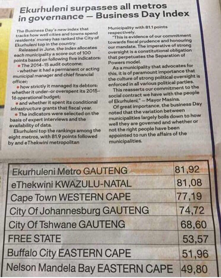
The city has scored best in governance out of all metros in South Africa.[34]
The municipal council consists of 224 members elected by mixed-member proportional representation. 112 are elected by first-past-the-post voting in 112 wards, while the remaining 112 are chosen from party lists so that the total number of party representatives is proportional to the number of votes received. In the election of 3 August 2016 the African National Congress (ANC) lost its majority on the council for the first time. The ANC subsequently formed a coalition with the African Independent Congress (AIC), the Pan Africanist Congress (PAC) and the Patriotic Alliance (PA).
The following table shows the results of the 2016 election.[35][36]
| Party | Votes | Seats | ||||||
|---|---|---|---|---|---|---|---|---|
| Ward | List | Total | % | Ward | List | Total | ||
| African National Congress | 436,190 | 438,961 | 875,151 | 48.6 | 76 | 33 | 109 | |
| Democratic Alliance | 307,664 | 306,709 | 614,373 | 34.2 | 35 | 42 | 77 | |
| Economic Freedom Fighters | 102,242 | 99,770 | 202,012 | 11.2 | 1 | 24 | 25 | |
| African Independent Congress | 14,709 | 14,810 | 29,519 | 1.6 | 0 | 4 | 4 | |
| Inkatha Freedom Party | 8,940 | 9,345 | 18,285 | 1.0 | 0 | 2 | 2 | |
| Freedom Front Plus | 7,991 | 8,059 | 16,050 | 0.9 | 0 | 2 | 2 | |
| African Christian Democratic Party | 3,908 | 3,754 | 7,662 | 0.4 | 0 | 1 | 1 | |
| Pan Africanist Congress | 3,836 | 3,743 | 7,579 | 0.4 | 0 | 1 | 1 | |
| Patriotic Alliance | 2,272 | 2,499 | 4,771 | 0.3 | 0 | 1 | 1 | |
| Congress of the People | 2,209 | 2,504 | 4,713 | 0.3 | 0 | 1 | 1 | |
| Independent Ratepayers Association of SA | 3,067 | 1,219 | 4,286 | 0.2 | 0 | 1 | 1 | |
| Independent | 3,675 | – | 3,675 | 0.2 | 0 | – | 0 | |
| United Democratic Movement | 1,435 | 2,109 | 3,544 | 0.2 | 0 | 0 | 0 | |
| Others | 2,283 | 5,298 | 7,581 | 0.4 | 0 | 0 | 0 | |
| Total | 900,421 | 898,780 | 1,799,201 | 100.0 | 112 | 112 | 224 | |
| Spoilt votes | 16,086 | 15,783 | 31,869 | |||||
Economy
As of 2014 the GDP of Ekurhuleni was estimated at over US$ 55 billion (PPP), being US$17,361 per person.[5] Ekurhuleni has an active workforce of 1.6 million people of whom 28.8% are unemployed.[26] Ekurhuleni makes up 6.2% of national production.
Ekurhuleni has in Rand Refinery the largest integrated single-site precious metals refining and smelting complex in the world.[37]
Manufacturing
The city is an important manufacturing centre in South Africa, contributing 32% of manufacturing production.[38] The city has been described as "the workshop of the country".[39] It contributes 11% to the GVA of South Africa.[40]
Ekurhuleni has held the "Manufacturing Indaba" Conference every year since 2014. This two-day conference provides contacts and networking between business owners, industry owners, capital providers, experts and the government.[41]
Infrastructure
Road network
Ekurhuleni is connected to the main motorways in South Africa via the M2,N3,N17,R21, R24, R59. The road network in Ekurhuleni spans 8,024 km of paved roads and approximately 1,200 km of gravel road.[42]
Public transport
Ekurhuleni is one of 13 cities and towns in South Africa to implement the bus rapid transit (BRT) system. Phase 1 of the project runs from Tembisa to Vosloorus via Kempton Park and the OR Tambo International Airport. New routes have been integrated from Katlehong to Rhodesfield, from Vosloorus to Rhodesfield, and from Reiger Park to Rhodesfield.[43] Passengers are served by Metrorail which sustains the passenger rail network in the Western Cape, Gauteng, KwaZulu-Natal and the Eastern Cape. Seven train lines serve Ekurhuleni.[44]
Rail
Ekurhuleni has the largest rail hub in South Africa used by Transnet.[38]
Aviation
Several airline companies are headquartered in the Kempton Park area of Ekurhuleni.
Ekurhuleni is Gauteng's first aerotropolis.[45] This is a metropolis with an airport at its centre. One should be able to get to the airport from anywhere in Ekurhuleni in 25 min. The major aim will be logistics and connecting the local industry and agriculture to the world markets.
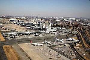
O.R. Tambo International Airport has two terminals handling domestic and international flights. Terminal A handles international traffic and Terminal B domestic flights. The airport services airlines from all five continents and plays a vital role in serving the local, regional, intra- and inter-continental air transport needs of South Africa and sub-Saharan Africa. It is the biggest and busiest airport in Africa. OR Tambo International handles more than 20 million passengers per year and employs more than 18,000 people.[46]
South African Airways, the flagship air carrier of South Africa, and its subsidiary South African Express Airways have their head offices in Ekurhuleni.[6][47][48] Mango, a low cost airline owned by SAA, is headquartered on the grounds of OR Tambo International Airport.[49]
The headquarters of Comair and Kulula.com are at an intersection within Ekurhuleni in close proximity to OR Tambo International Airport.[50][51] Federal Air also has its headquarters on the OR Tambo International Airport grounds.[52] 1Time has its head office in the Isando Industrial Park.[53] Safair's head office is in Kempton Park.[54]
Airports Company South Africa has its head office in Bedfordview, Ekurhuleni.[55] TAAG Angola Airlines has an office in Bedfordview.[56]
Stormwater systems
There are 11,318 stormwater systems and a total lengths of pipes and channels of more than 3800 km.[42]
Sports and recreation
Ekurhuleni has at least 16 golf courses and is home to the international Golf Tournament the South African Open held at Glendower Golf Club.[57]
There is an over 100 year old rowing club at the bank of Germiston Lake,[58] and over 30 swimming pools can be found in the city.[59]
Ekurhuleni United FC play in the fourth division of South African Football.[60]
Ekurhuleni has the Ekurhuleni masters league, a soccer league of retired pros and talented players who didn't make the cut.[61]
38 eco "outdoor gyms" can be found in Ekurhuleni.
Notable people from Ekurhuleni
- Willem Coertzen
- Ernie Els
- Chris Hani
- Sibusiso Khumalo
- Kwesta
- Sbusiso Leope
- Senzo Meyiwa
- Pearl Modiadie
- Khethi Ngwenya
- Charlize Theron
- Oliver Tambo
- Vusi Thembekwayo
References
- ↑ "Contact list: Executive Mayors". Government Communication & Information System. Archived from the original on 14 July 2010. Retrieved 22 February 2012.
- ↑ "As it happened: ANC wins Ekurhuleni municipality mayoral race".
- 1 2 "Statistics by place". Statistics South Africa. Retrieved 27 September 2015.
- ↑ "Statistics by place". Statistics South Africa. Retrieved 27 September 2015.
- 1 2 3 "Global city GDP 2014". Brookings Institution. Retrieved 7 November 2017.
East Rand
- 1 2 "Background." Ekurhuleni. 3 (3/8). Retrieved on 30 September 2009.
- ↑ "IDP & SDBIP 2013/14". Ekurhuleni Metropolitan Municipality. 2013. p. 11.
- ↑ "DA wins court case - Heidelberg Nigel Heraut". 22 September 2015.
- ↑ "Xenophobia: The painful history of black-on black violence - OPINION - Politicsweb". www.politicsweb.co.za.
- ↑ CITY OF EKURHULENI [@City_Ekurhuleni] (25 July 2017). "@morri85 Giloolys ridge – Bill Stewart Side –Fishers hill is highest point at +/- 1772m Lowest point is about +/- 1552m 👍🏼" (Tweet) – via Twitter.
- ↑ "Archived copy". Archived from the original on 2017-08-31. Retrieved 2017-07-25.
- ↑ https://web.archive.org/web/20170831092711/http://www.arcgis.com/home/webmap/viewer.html?webmap=a71c14fe019f489da7522a038430e6cf]
- ↑ |page5
- ↑ "Climate Germiston". meteoblue.
- ↑ "".
- ↑ "Climate Germiston". Retrieved 24 July 2017.
- ↑ "UNdata|record view|Sunshine". United Nations Statistics Division. Retrieved 24 July 2017.
- ↑ Lookup Tables - Statistics South Africa
- ↑ "Data" (PDF). www.wrc.org.za.
- ↑ "Ekurhuleni – Gauteng Tourism Authority". www.gauteng.net.
- ↑ "Archived copy". Archived from the original on 2017-08-08. Retrieved 2017-07-24.
- 1 2 3 "Story Map Journal".
- ↑ "Thami Mnyele Fine Art Awards 2017 Competition - Art.co.za - Art in South Africa". www.art.co.za.
- ↑ "Archived copy". Archived from the original on 2017-12-04. Retrieved 2017-11-25.
- ↑ "City of Ekurhuleni Metropolitan Municipality - Overview". Localgovernment.co.za. Retrieved 2018-07-22.
- 1 2 Statistics South Africa. "Local Municipality | Statistics South Africa". Statssa.gov.za. Retrieved 2018-07-22.
- ↑ "Education Districts". www.education.gov.za.
- ↑ "Archived copy". Archived from the original on 2018-07-22. Retrieved 2017-07-24.
- ↑ "Archived copy". Archived from the original on 2018-07-22. Retrieved 2017-07-24.
- ↑ "Archived copy". Archived from the original on 2018-07-22. Retrieved 2017-07-24.
- ↑ "Archived copy". Archived from the original on 2018-07-22. Retrieved 2017-07-24.
- ↑ "Archived copy" (PDF). Archived from the original (PDF) on 2017-08-09. Retrieved 2017-07-24.
- ↑ "Symposium CoE University". City of Ekurhuleni. CoE. Retrieved 18 November 2017.
- ↑ "Info" (JPG). pbs.twimg.com.
- ↑ "Results Summary – All Ballots: Ekurhuleni" (PDF). Independent Electoral Commission. Retrieved 26 December 2016.
- ↑ "Seat Calculation Detail: Ekurhuleni" (PDF). Independent Electoral Commission. Retrieved 26 December 2016.
- ↑ www.sonaruniversal.co.za, Susan Craig, Sonar Universal,. "About Us : Our Company". www.randrefinery.com.
- 1 2 "Data" (PDF). www.nwu.ac.za.
- ↑ thamashni naidoo. "Ekurhuleni – still South Africa's manufacturing powerhouse". Engineeringnews.co.za. Retrieved 2018-07-22.
- ↑ CITY OF EKURHULENI [@City_Ekurhuleni] (27 June 2017). "Manufacturing in #InvestCoE Constitutes 27,9 % GVA and 11% SA's GVA. #MI2017" (Tweet) – via Twitter.
- ↑ "Home - Manufacturing Indaba". Manufacturing Indaba.
- 1 2 "Annual report" (PDF). mfma.treasury.gov.za. 2016.
- ↑ About The Author Glen Tancott. "Developing a critical hub in Ekurhuleni". Infrastructure news. Retrieved 2018-07-22.
- ↑ "Archived copy". Archived from the original on 2010-02-09. Retrieved 2010-08-09.
- ↑ "Archived copy". Archived from the original on 2018-03-16. Retrieved 2017-07-20.
- ↑ "Archived copy". Archived from the original on 2018-03-16. Retrieved 2017-07-25.
- ↑ "Legal Information - (EU) Archived 2009-09-12 at the Wayback Machine.." South African Airways. Retrieved on 24 June 2009.
- ↑ "Contact Us Archived 2008-05-09 at the Wayback Machine.." South African Express. Retrieved on 30 September 2009.
- ↑ "Contact Us Archived 2009-09-16 at the Wayback Machine.." Mango. Retrieved on 30 September 2009. "Mezzanine Level Domestic Departure Terminal OR Tambo International Airport 1627"
- ↑ "Contact Us Archived 2009-04-18 at the Wayback Machine.." Comair. Retrieved on 30 September 2009.
- ↑ "Contact Us." Kulula.com. Retrieved on 30 September 2009.
- ↑ "Contact details Archived 2009-09-17 at the Wayback Machine.." Federal Air. Retrieved on 30 September 2009.
- ↑ "Contact Us Archived 2011-05-31 at the Wayback Machine.." 1Time. Retrieved on 28 October 2009.
- ↑ "Contact." Safair. Retrieved on 1 March 2010.
- ↑ "Contact us Archived 2011-07-20 at the Wayback Machine.." Airports Company South Africa. Retrieved on 6 February 2011. "Physical address: 24 Johnson Road The Maples Office Park - Bedfordview Johannesburg."
- ↑ "TAAG Offices Archived 2010-01-29 at the Wayback Machine.." TAAG Angola Airlines. Retrieved on 23 January 2010.
- ↑ "Glendower Golf Club – Gauteng Tourism Authority". www.gauteng.net.
- ↑ "Victoria Lake Rowing Club, Germiston > Home". Vlc-rowing.co.za. Retrieved 2018-07-22.
- ↑ "EKURHULENI COMMUNITY POOLS READY AND SET FOR THE SWIMMING SEASON".
- ↑ "SAB League Ekurhuleni - Ekurhuleni City FC". ekurhuleni.leaguerepublic.com.
- ↑ "Fixtures – Ekurhuleni Master's League". Ekfleague.co.za. Retrieved 2018-07-23.
Sources
External links
- City of Ekurhuleni Metropolitan Municipality - official site of the City of Ekurhuleni Metropolitan Municipality
- History of Ekurhuleni
- Integrated Transport Plan
- Official statement on substituting Ekurhuleni Metropolitan Municipality with City of Ekurhuleni Metropolitan Municipality