Elliott, Maryland
| Elliott, Maryland | |
|---|---|
| Census-designated place | |
 Elliott Location in Maryland  Elliott Elliott (the US) | |
| Coordinates: 38°18′36″N 75°59′47″W / 38.31000°N 75.99639°WCoordinates: 38°18′36″N 75°59′47″W / 38.31000°N 75.99639°W | |
| Country | United States |
| State | Maryland |
| County | Dorchester |
| Area | |
| • Total | 0.3 sq mi (0.9 km2) |
| • Land | 0.3 sq mi (0.9 km2) |
| • Water | 0.0 sq mi (0.0 km2) |
| Elevation | 4 ft (1 m) |
| Population (2010) | |
| • Total | 52 |
| • Density | 148/sq mi (57.2/km2) |
| Time zone | UTC−5 (Eastern (EST)) |
| • Summer (DST) | UTC−4 (EDT) |
| ZIP code | 21869 |
| Area code(s) | 410, 443, and 667 |
| FIPS code | 24-26026 |
| GNIS feature ID | 590196 |
Elliott is an unincorporated community and census-designated place (CDP) in Dorchester County, Maryland, United States.[1] The population was 52 at the 2010 census.[2]
Geography
Elliott is located in southern Dorchester County on Elliott Island, on the east side of Fishing Bay. Elliott Island Road is the only road access to the town, leading 19 miles (31 km) northeast to U.S. Route 50 at Vienna.
According to the United States Census Bureau, the Elliott CDP has a total area of 0.36 square miles (0.92 km2), of which 73,250 square feet (6,805 m2), or 0.74%, is water.[2]
References
- ↑ U.S. Geological Survey Geographic Names Information System: Elliott, Maryland
- 1 2 "Geographic Identifiers: 2010 Demographic Profile Data (G001): Elliott CDP, Maryland". U.S. Census Bureau, American Factfinder. Retrieved October 29, 2015.
Municipalities and communities of Dorchester County, Maryland, United States | ||
|---|---|---|
| City | 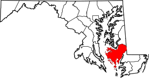 | |
| Towns | ||
| CDP | ||
| Other communities | ||
| Footnotes | ‡This populated place also has portions in an adjacent county or counties | |
This article is issued from
Wikipedia.
The text is licensed under Creative Commons - Attribution - Sharealike.
Additional terms may apply for the media files.