Crapo, Maryland
| Crapo, Maryland | |
|---|---|
| Unincorporated community | |
 Crapo | |
| Coordinates: 38°19′11″N 76°07′52″W / 38.31972°N 76.13111°WCoordinates: 38°19′11″N 76°07′52″W / 38.31972°N 76.13111°W | |
| Country | United States |
| State | Maryland |
| County | Dorchester |
| Elevation | 0 ft (0 m) |
| Time zone | UTC-5 (Eastern (EST)) |
| • Summer (DST) | UTC-4 (EDT) |
| ZIP code | 21626 |
| Area code(s) | 410, 443, and 667 |
| GNIS feature ID | 590040[1] |
Crapo is an unincorporated community in Dorchester County, Maryland, United States.[1] Crapo is located along Lakesville-Crapo Road on the east bank of the Honga River in the southern part of the county. It has frequently been noted on lists of unusual place names.[2] The name Crapo comes from "crapaud", which is the French word for toad.[1]
References
- 1 2 3 "Crapo". Geographic Names Information System. United States Geological Survey.
- ↑ Parker, Quentin (2010). Welcome to Horneytown, North Carolina, Population: 15: An insider's guide to 201 of the world's weirdest and wildest places. Adams Media. pp. ix.
Municipalities and communities of Dorchester County, Maryland, United States | ||
|---|---|---|
| City | 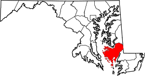 | |
| Towns | ||
| CDP | ||
| Other communities | ||
| Footnotes | ‡This populated place also has portions in an adjacent county or counties | |
This article is issued from
Wikipedia.
The text is licensed under Creative Commons - Attribution - Sharealike.
Additional terms may apply for the media files.