Elgin Bridge (Singapore)
Coordinates: 1°17′20.6″N 103°50′57.3″E / 1.289056°N 103.849250°E
| Elgin Bridge 爱琴桥 | |
|---|---|
 | |
| Coordinates | 1°17′21″N 103°50′56″E / 1.28906°N 103.849°ECoordinates: 1°17′21″N 103°50′56″E / 1.28906°N 103.849°E |
| Carries | Motor vehicles and pedestrians |
| Crosses | Singapore River |
| Locale | Singapore River, Singapore |
| Official name | Elgin Bridge |
| Characteristics | |
| Design | Arch bridge |
| Total length | 46 metres |
| Width | 25 metres |
| History | |
| Opened | 1929 |
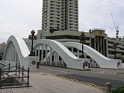
Elgin Bridge is a vehicular bridge across the Singapore River, linking the Downtown Core to the Singapore River Planning Area located within Singapore's Central Area.
The bridge was named after Lord Elgin, Governor-General of India (21 March 1862 - 20 November 1863) in 1862 when an iron bridge was built across the river, replacing an older wooden bridge. The current bridge was built in 1929.[1] As this was the first bridge across the river, the two roads leading to it were named North Bridge Road and South Bridge Road accordingly.
History
In 1819, Sir Thomas Stamford Raffles landed on Singapore and founded the colony. Raffles issued an instruction on 25 June 1819 that a bridge be built as soon as possible across the Singapore River so that it may link a town planned for the Chinese community on the southern side of the river to another intended for the Malays on the northern side.[2]
In 1822, a wooden footbridge was built under the direction of Lieutenant Philip Jackson and it was officially named Presentment Bridge.[1][3] It was also known as Jackson's Bridge and Monkey Bridge.[4]
In 1844, a wooden footbridge built by John Turnbull Thomson replaced the older bridge, and was named Thomson's Bridge.[1] This was demolished in 1862; in its place an iron bridge was built and named Elgin Bridge after James Bruce, 8th Earl of Elgin, Governor General of India. It was widened in the 1870s. In 1925 the iron bridge had to make way for a new concrete bridge, which was opened to traffic by the Governor of the Straits Settlements Sir Hugh Clifford on 30 May 1929.[4]
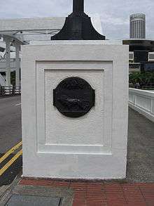
Cavaliere Rudolfo Nolli, an Italian sculptor, designed the cast iron lamps on both sides of the bridge. His signature is inscribed beneath the lamps. Bronze plaques, each with a lion standing in front of a royal palm tree engraved on it, can also be found below the lamps.
Elgin Bridge is known as thih tiau kio in Hokkien, meaning "iron suspension bridge".[4]
On 3 November 2008, the bridge was selected for conservation as part of the Urban Redevelopment Authority's expanded conservation programme.[5]
References
- 1 2 3 Vernon Cornelius-Takahama. "Elgin Bridge". Singapore Infopedia. National Library Board.
- ↑ Charles Burton Buckley (1902). An anecdotal history of old times in Singapore. p. 58.
- ↑ G. Chandradas, Tien Chung Ping (21 August 2008). "Bridging the gap", The Straits Times.
- 1 2 3 Victor R Savage, Brenda S A Yeoh (2004). Singapore Street Names — A Study of Toponymics. Eastern University Press. pp. 110–111. ISBN 981-210-364-3.
- ↑ Tay Suan Chiang (4 October 2008). "Twelve iconic structures". Straits Times. Archived from the original on 7 October 2008.
See also
| Wikimedia Commons has media related to Elgin Bridge. |
External links
- "Elgin Bridge". Roots. National Heritage Board.
Bridges on the Singapore River | ||
|---|---|---|