Electoral division of Apsley
| Apsley Tasmania—Legislative Council | |
|---|---|
 | |
| State | Tasmania |
| Created | 1999 |
| Abolished | 2017 |
| Namesake | Apsley River (Lord Apsley) |
| Electors | 23,424 (January 2015) |
| Area | 19,204 km2 (7,414.7 sq mi) |
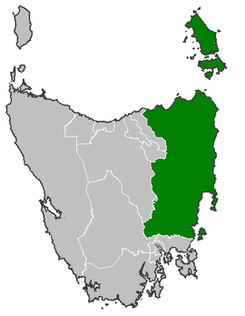
The electoral division of Apsley was an electorate of the Tasmanian Legislative Council, it was created in 1999 and abolished in 2017.
The total area of the division is 19,204 square kilometres (7,415 sq mi).[1][2] As of 31 January 2015, there were 23,424 enrolled voters in the division.[3]
The division was created in 1999 and named after the Apsley River, named after Lord Apsley, Earl Bathurst, and includes the towns of Pipers River, Scottsdale, Evandale, Swansea, Derby, Lilydale, Bridport, Campbell Town, Colebrook, St Helens, Branxholm, Avoca, Fingal, Bicheno, Bagdad, Bellingham, Tomahawk, Ross, St Marys, Rossarden and many others.[1]
Members
| Member | Party | Term | |
|---|---|---|---|
| Colin Rattray | Independent | 1999–2004 | |
| Tania Rattray(-Wagner) | Independent | 2004–2017 | |
See also
References
- 1 2 "Division of Apsley" (Map). Maps of the divisions. Tasmanian Electoral Commission. 10 May 2008. Retrieved 12 August 2015.
- ↑ "Redistribution Determination May 2008 - Summary of Divisions" (PDF). Tasmanian Electoral Commission. 10 May 2008. Retrieved 12 August 2015.
- ↑ "Legislative Council Divisional Enrolment as at 31 January 2015" (PDF) (Map). Legislative Council Enrolment. Tasmanian Electoral Commission. 2 February 2015. Retrieved 12 August 2015.
External links
East Coast region of Tasmania, Australia | |||||
|---|---|---|---|---|---|
| Settlements | |||||
| Governance former | |||||
| Mountains | |||||
| Protected areas, parks and reserves | |||||
| Harbours, bays, inlets and estuaries | |||||
| Landmarks |
| ||||
| People of note | |||||
| Islands |
| ||||
| Books and newspapers | |||||
| Flora, fauna, and fishlife | |||||
| Bioregions | |||||
| |||||
This article is issued from
Wikipedia.
The text is licensed under Creative Commons - Attribution - Sharealike.
Additional terms may apply for the media files.