Elder's Mill Covered Bridge and Elder Mill
|
Elder's Mill Covered Bridge and Elder Mill | |
 | |
 | |
| Nearest city | Watkinsville, Georgia |
|---|---|
| Coordinates | 33°48′11″N 83°21′49″W / 33.80306°N 83.36361°WCoordinates: 33°48′11″N 83°21′49″W / 33.80306°N 83.36361°W |
| Area | 6 acres (2.4 ha) |
| Built | 1897 |
| Built by | Richardson, Nathaniel; Hunt and Durham |
| NRHP reference # | 94000389[1] |
| Added to NRHP | May 5, 1994 |
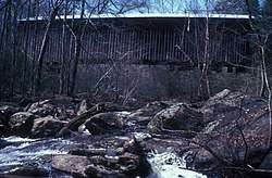
Elder's Mill Covered Bridge and Elder Mill, near Watkinsville, Georgia, was listed on the National Register of Historic Places in 1994.[1]
It is located on Elder Mill Rd., 4/5 mi. south of its junction with GA 15. The listing includes the covered bridge built in 1897 and a c.1900 three-story wood-frame mill building. The bridge was built in 1897 by Nathaniel Richardson to bring the Watkinsville-Athens Road across Call Creek in Clarke County, and was moved in 1924 to its current location spanning Rose Creek in Oconee County. The bridge is a 99 feet (30 m) long Town lattice truss covered bridge.[2]
References
- 1 2 National Park Service (2013-11-02). "National Register Information System". National Register of Historic Places. National Park Service.
- ↑ Leslie N. Sharp (March 14, 1994). "National Register of Historic Places Registration: Elder's Mill Covered Bridge and Elder Mill". National Park Service. Retrieved September 12, 2018. With accompanying 14 photos
| Topics | |
|---|---|
| Lists by states |
|
| Lists by insular areas | |
| Lists by associated states | |
| Other areas | |
| |
This article is issued from
Wikipedia.
The text is licensed under Creative Commons - Attribution - Sharealike.
Additional terms may apply for the media files.