Elamville, Alabama
| Elamville, Alabama | |
|---|---|
| Unincorporated community | |
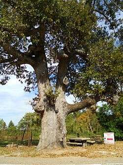 The "Old Oak Tree" | |
 Elamville, Alabama  Elamville, Alabama | |
| Coordinates: 31°40′04″N 85°39′23″W / 31.66778°N 85.65639°WCoordinates: 31°40′04″N 85°39′23″W / 31.66778°N 85.65639°W | |
| Country | United States |
| State | Alabama |
| County | Barbour |
| Elevation | 522 ft (159 m) |
| Time zone | UTC-6 (Central (CST)) |
| • Summer (DST) | UTC-5 (CDT) |
| Area code(s) | 334 |
| GNIS feature ID | 117907[1] |
Elamville is an unincorporated community in the southwest corner of Barbour County, Alabama, United States. In the early to mid-20th century Elamville was known for the "Old Oak Tree" in the middle of town where the elderly men of the community played dominoes on the state- provided concrete picnic table.
References
Municipalities and communities of Barbour County, Alabama, United States | ||
|---|---|---|
| Cities | 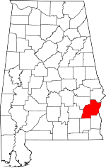 | |
| Towns | ||
| Unincorporated communities | ||
This article is issued from
Wikipedia.
The text is licensed under Creative Commons - Attribution - Sharealike.
Additional terms may apply for the media files.