Bakerhill, Alabama
Coordinates: 31°53′06″N 85°09′14″W / 31.88495°N 85.15390°W
| Bakerhill, Alabama | |
|---|---|
| Town | |
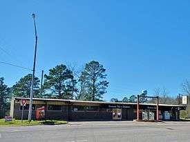 Bakerhill in 2012 | |
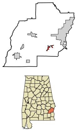 Location of Bakerhill in Barbour County, Alabama. | |
 Bakerhill, Alabama Location of Bakerhill in Barbour County, Alabama. | |
| Coordinates: 31°46′53″N 85°18′08″W / 31.78139°N 85.30222°W | |
| Country | United States |
| State | Alabama |
| County | Barbour |
| Area[1] | |
| • Total | 2.75 sq mi (7.13 km2) |
| • Land | 2.75 sq mi (7.13 km2) |
| • Water | 0.00 sq mi (0.00 km2) |
| Elevation | 535 ft (163 m) |
| Population (2010)[2] | |
| • Total | 279 |
| • Estimate (2017)[3] | 255 |
| • Density | 92.69/sq mi (35.78/km2) |
| Time zone | UTC-6 (Central (CST)) |
| • Summer (DST) | UTC-5 (CDT) |
| Area code(s) | 334 |
| FIPS code | 01-03724 |
| GNIS feature ID | 154970[4] |
Bakerhill or Baker Hill is a town in Barbour County, Alabama, United States, near Eufaula. According to the 2010 U.S. Census, the town had a population of 279.[2] Although it existed as an unincorporated village since before 1860, the town was officially incorporated in 1997.
Geography
Bakerhill is located at 31.88 degrees north, 85.15 degrees west (31.88495, -85.15390).[5]
The surrounding countryside is mostly rolling hills covered in mostly in pine forest. Small-scale logging, as well as bauxite mining and minor livestock raising activities account for most of the local area's business activities. The town also, as of 2009, includes two gas stations as well as a grill & bar and a small, family owned and operated deer processing business. There is also a small feed mill.
The soil is mostly reddish clay and sand. Numerous Native American artifacts have been discovered there.
Demographics
| Historical population | |||
|---|---|---|---|
| Census | Pop. | %± | |
| 2010 | 279 | — | |
| Est. 2017 | 255 | [3] | −8.6% |
| U.S. Decennial Census[6] | |||
See also
References
- ↑ "2017 U.S. Gazetteer Files". United States Census Bureau. Retrieved Jul 7, 2018.
- 1 2 "American FactFinder". United States Census Bureau. Archived from the original on 2013-09-11. Retrieved 2011-05-14.
- 1 2 "Population and Housing Unit Estimates". Retrieved March 24, 2018.
- ↑ "Baker Hill". Geographic Names Information System. United States Geological Survey.
- ↑ "US Gazetteer files: 2010, 2000, and 1990". United States Census Bureau. 2011-02-12. Retrieved 2011-04-23.
- ↑ "Census of Population and Housing". Census.gov. Archived from the original on May 12, 2015. Retrieved June 4, 2015.
External links
- Zone 1 News - Breaking News, Investigative Reports, Video Coverage
- Brief information about Bakerhill
- Bakerhill profile from Alabama.gov
Municipalities and communities of Barbour County, Alabama, United States | ||
|---|---|---|
| Cities |  | |
| Towns | ||
| Unincorporated communities | ||