El Sur Ranch
| Industry | Cow-calf operation |
|---|---|
| Predecessor | Rancho El Sur |
| Founded | 1955 |
| Founder | Courtlandt Hill |
| Headquarters | Big Sur, California, U.S. |
Area served | United States |
| Products | Beef |
| Revenue | $243,000 to $760,000 |
| Owner | James Jerome Hill III |
Number of employees | 2-5 |
| Website |
www |
The El Sur Ranch, located on the Big Sur coast of California, has been continuously operated as a cattle ranch since 1834. It straddles Highway 1 for 6 miles (9.7 km) from the mouth of the Little Sur River to the mouth of the Big Sur River and Andrew Molera State Park. Both the ranch and the park originally comprised the Rancho El Sur land grant given in 1834 by Governor José Figueroa to Juan Bautista Alvarado. It has been owned by the Hill family since 1955, who operate a commercial cow-calf operation.
Upon inheriting the ranch while still in college and pressed by increasingly high property taxes, the ranch's current owner James Hill began plans to develop two percent of the property. His plans were protested by Big Sur residents whose efforts persuaded the California Coastal Commission to deny his permit. In 1997, after being denied a permit to build a 200 room hotel at the mouth of Little Sur River, he agreed to a conservation easement covering almost all of the property visible from Highway 1 at a cost of $11 million to California taxpayers. The land has historically used water from the Big Sur River, or from wells drilled in 1949 (old well) and 1984 (new well), and Hill has sought to increase diversion from the river to levels that would eliminate passage for endangered steelhead trout.
Location
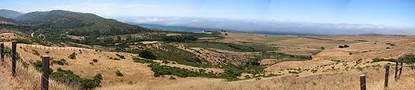
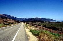
Most of the original grant is now part of the 7,100 acres (2,873 ha) El Sur Ranch alongside Highway 1 today, comprising 13 original parcels partitioned on March 21, 1891.[1] The ranch, which includes 12% of the private land in Big Sur, straddles 6 miles (9.7 km) of Highway 1 stretching south from Hurricane Point north of the mouth of the Little Sur River to near the Big Sur River in Andrew Molera State Park, and it reaches 2.5 miles (4.0 km) inland over the coastal mountains into the south fork of the Little Sur valley to the border of the Los Padres National Forest.[2][3][4]
Etymology
The Spanish referred to the vast, relatively unexplored, coastal region to the south of their capital Monterey as el país grande del sur, meaning "the big country of the south". This was often shortened to el sur grande.[5][6] The two major rivers were named El Rio Grande del Sur and El Rio Chiquito del Sur.[6]:7
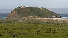
The first recorded use of the name "el Sud" (meaning "the South") was on a map of Rancho El Sur land grant given by Governor José Figueroa to Juan Bautista Alvarado on July 30, 1834.[7] The first American use of the name "Sur" was by the U.S. Coast Survey in 1851, which renamed a point of land that looked like an island and was shaped like a trumpet, formerly known as "Morro de la Trompa" and "Punta que Parece Isla" during Spanish times, to Point Sur.[8] The island was later graded to provide flat land for the Point Sur Light Station.
History
Before the arrival of Europeans, the land was occupied by the Esselen people, who resided along the upper Carmel and Arroyo Seco Rivers, and along the Big Sur coast from near present-day Hurricane Point to the vicinity of Vicente Creek in the south.[9] The native people were heavily affected by the establishment of three Spanish Missions near them from 1770 to 1791.[9] The native population was decimated by disease, including measles, smallpox, and syphilis, which wiped out 90 percent of the native population,[10]: and by conscript labor, poor food, and forced assimilation. Most of the Esselen people's villages within the current Los Padres National Forest were left largely uninhabited.[11]
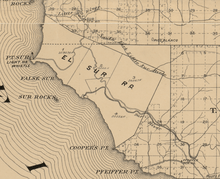
Spanish Governor José Figueroa granted two square leagues (totalling 8,949 acres (36.22 km2)) of land named Rancho El Sur in 1834 to Juan Bautista Alvarado, who later traded it to his uncle Juan Bautista Rogerio Cooper in exchange for Rancho Bolsa del Potrero. As required by the Land Act of 1851, Cooper filed a claim for Rancho El Sur with the Public Land Commission in 1852,[12] and after year of litigation he received the legal land patent in 1866.[13]
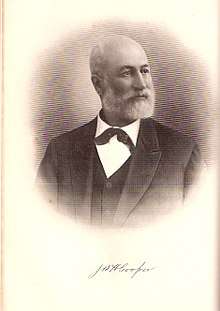
John B.R. Cooper married Geronima de la Encarnacion Vallejo. They had six daughters and one son.[14] Their son John Baptist Henry Cooper helped his father with the cattle business on Rancho El Sur. He also successfully managed other lands owned by the family in the Salinas Valley. He married Martha Brawley in 1871 and was elected as a Monterey County supervisor. Upon John B.R. Cooper's death in 1872, the ranch was divided between his widow, their son John Baptist Henry Cooper, and their two surviving daughters, Anna Maria de Guadalupe Cooper and Francisca Guadalupe Amelia Cooper.[15]
John Baptist Henry Cooper built a new home on Rancho El Sur Ranch but died soon after its completion on June 21, 1899, leaving the ranch to his wife.[15] Martha (Brawley) Cooper received 2,591 acres (1,049 ha) of her husband's estate totaling 7,000 acres (2,800 ha), and over time bought the remainder from her husband's two sisters.[16][17] She sold 5000 acres in 1928 to businessman Harry C. Hunt of Carmel-by-the-Sea.
Modern ownership
Louis W. Hill, the son of railroad magnate James J. Hill,[18][19] began spending the winter in Pebble Beach with his family around 1910, including his son Cortlandt T. Hill, and Louis bought considerable land in the area.[20] Cortlandt spent most of his life in California and built a house in Pebble Beach. Cortlandt's first wife Blanche Ellen (née Wilbur) was previously married to George Randolph Hearst, the eldest son of publishing tycoon William Randolph Hearst. The elder Hearst had nurtured an ambition to buy large areas of the Big Sur coast at one time. Blanche married Cortlandt Hill on March 31, 1934, at the Ritz Tower on Park Avenue in New York City. They divorced in 1952.[18] Cortlandt married Marion Ballaire in 1953. They had three children, including James Jerome Hill III, named after his uncle and great-grandfather.[21][22]
In 1955 Cortlandt bought the El Sur Ranch from Harry C. Hunt.[23] His son James spent many weekends and summer vacations on the ranch. Cortlandt and Marion were divorced in March 1972.[24] Cortlandt married Blanche C. Hauserman (née Christian) on January 9, 1973. She had opened the first commercial building and ski shop at Vail Ski Resort,[25] and both were enthusiastic leaders in the snow skiing community.[26][27]
Conservation easement
When Cortlandt died on March 28, 1978, his son James inherited the land while he was still in college.[28] James faced inheritance and property taxes that exceeded cash on hand. He contracted with a San Francisco architectural firm to develop a plan for the property that would produce income but keep it undivided and devoted to cattle ranching.[3]
In August 1983, the California Coastal Conservancy announced they had agreed to pay Hill $1 million for a conservation and scenic easement on 1,400 acres (570 ha) on the east side of Highway 1, south of Little Sur River, and to purchase 1,200 acres (490 ha). Hill also agreed to donate the cost of a conservation easement on another 1,100 acres (450 ha). Hill retained the right to develop the remaining 3,400 acres (1,400 ha). Hill initially proposed a 200 room hotel, conference center, and restaurant on land west of Highway 1 adjacent to the Little Sur River, and a cabin complex on the east side hidden from the highway. He later submitted a revised plan to Monterey County for a 100 room hotel in three or four buildings and a 200 seat restaurant, plus 98 private home sites situated so they could not be seen from Highway 1. The development would have utilized two percent of the property. He also sought a conservation easement on 3,000 acres (1,200 ha). The Monterey County Board of Supervisors approved the plan in 1984.[4][3]
There was considerable local opposition. Fifty Big Sur residents attended a meeting of the Coastal Commission in April 1985 to protest the development plans. The Big Sur Land Trust also voiced their opposition. The Big Sur Local Use Plan was under consideration by the California Coastal Commission, and the supervisors withdrew it. The fight over Hill's development rights played a role in tightening rules in the Big Sur Local Coastal Plan. The county conducted additional hearings and modified the land use plan to further restrict larger developments. The Coastal Commission accepted the revised land use plan and rejected Hill's application for a permit.[3]
In 1991, Hill began negotiating with the Big Sur Land Trust for a conservation easement on 3,550 acres (1,440 ha) of land visible to the public, including all of the lands west of Highway 1.[28][29] Monterey County eventually agreed to pay $11.5 million to Hill for a conservation easement. This was almost half of the $25 million set aside by a 1988 parks bond initiative (Proposition 70) to preserve Big Sur land. The payment was the largest in California history. In exchange, Hill and any future owner give up the right to develop the acres included in the easement.[30] It gave Hill a one-time tax credit of $4.5 million, the difference between the prior market value and the value after the ability to develop the land was removed. He also receives the benefit of an ongoing reduction in property taxes.[31][32]
Current operations
Hill continues to run a commercial cow-calf operation with about 450 head on the ranch. The cattle graze on natural grasslands in the mountains on the east side of Highway 1 until the fields dry during the spring, when the cattle are relocated to pasture on eleven fenced and irrigated fields totaling 267 acres (108 ha) on the west side of Highway 1.[28][28] Hill lives in the family residence in Pebble Beach, California, on the Monterey Peninsula.[28][33] Public records estimate his business Hill Properties grosses from $243,000 to $760,000 a year from its land, cattle and other operations.[34][35]
Water rights litigation
In 1905, Martha Cooper Vasquez, John B. H. Cooper's widow, was granted a permit to use water from the Big Sur River to irrigate land along the coast. In 1928, after Harry Hunt bought the land, he began raising alfalfa, barley, corn, potatoes and carrots. In 1938 he returned to raising feed for cattle.[23] Hill irrigates 267 acres (108 ha) with water from two wells near the Big Sur River.[36]
In 1990, the California Department of Water Resources filed a complaint with the California State Water Resources Control Board stating that the El Sur Ranch's wells were drawing water from the underflow of the Big Sur River, and Hill was required to apply for a Water Right Permit.[28] Hill has supplied studies that contradict the state's findings, and has been engaged in ongoing litigation and negotiations with the California Department of Fish and Wildlife. He is seeking a permit to use a maximum of 1,615 acre-feet per year, based on a 20-year rolling average of 1,200 acre-feet per year.[37] The California Department of Parks and Recreation, the California Department of Fish and Game, and the California Sportfishing Protection Alliance claim the water Hill is diverting is reducing the flow of the Big Sur River and harming the threatened steelhead habitat.[36]
Hill is striving to preserve his right to use water that the ranch must have access to if it is to continue operations. The ranch has relied on water from the Big Sur River or from permitted wells near the river from the time of the original land grant.[38][39]
Community service
Hill has allowed fire services to use his ranch as a base of operations during fires. During the Soberanes Fire in 2016, a fire retardant base operated out of the ranch.[40] He has also allowed helicopters to draw water from his ponds for firefighting efforts.[41] Hill privately donated over $100,000 to buy and refurbish a surplus MRAP for use by the Del Rey Oaks and neighboring police departments. Hill is a volunteer on the city's police reserve force. He agreed through his company NorthTree Fire International to maintain the vehicle for five years.[42] The Ventana Wildlife Society has been engaged since 1996 in a program to restore the California condor population from near extinction. Hill allows the society to use a ranch road to deliver animal carcasses for the condors to feed on to a location outside the ranch. Hill later established a second feeding location near by on his land where he has brought carcasses of his own cattle to feed the condors. In 2011, he told a reporter that "Over the last six or seven years, we've delivered 30,000 to 40,000 pounds of carcasses." To prevent the Condors from ingesting lead, Hill has also instructed his employees to use copper bullets when protecting the cattle from predators.[43]
Public access
The Little Sur Trail begins on the Old Coast Road within the boundaries of the El Sur Ranch. While California passed a law supporting a coastal trail within view of the ocean, the El Sur Ranch is already crossed by two public routes, Highway 1 and the Old Coast Road. Hill is opposed to another public right-of-way through the ranch.[44]
The mouth of the Little Sur River and the mile-long Little Sur River beach are within the boundaries of the El Sur Ranch, and Hill has posted no trespassing signs prominently on the fence along Highway 1. While the beach below the mean high tide line is open to the public, the law does not permit individuals to trespass on private property to reach the public beach. Individuals who trespass to reach the beach have been cited.[45][46]
References
- ↑ California. Court of Appeal (6th Appellate District). Records and Briefs: H004844, Judicial Notice. Retrieved 12 February 2018.
- ↑ "State Parks to Acquire Garrapata, Little Sur, and J.P. Bums Extension" (PDF). Big Sur Gazette. Archived (PDF) from the original on 7 February 2016. Retrieved 14 August 2016.
- 1 2 3 4 Brooks, Shelley Alden (2017). Big Sur: The Making of a Prized California Landscape. University of California Press. ISBN 9780520967540. Retrieved 13 February 2018.
- 1 2 walton, John (2007). "The Land of Big Sur Conservation on the California Coast" (PDF). California History. 85 (1). Archived from the original (PDF) on August 22, 2015e. Retrieved 14 August 2016.
- ↑ "History of Big Sur California". bigsurcalifornia.org. Archived from the original on 2016-08-01. Retrieved 2016-09-06.
- 1 2 Jensen, Jamie Road Trip USA: Cross-Country Adventures on America's Two-Lane Highways Archived 2016-11-30 at the Wayback Machine.
- ↑ "Diseño del parage llamado el Sud y solicitado por Juan Bauta. Alvarado: [Rancho El Sur, Calif.]". United States District Court (California: Southern District).
- ↑ Gudde, Erwin Gustav (1998). California Place Names: The Origin and Etymology of Current Geographical Names. Bright, William (fourth, rev. and enl. ed.). Berkeley: University of California Press. p. 379. ISBN 9780520266193. OCLC 37854320. Archived from the original on 2018-01-09.
- 1 2 Breschini, Gary S.; Trudy Haversat. "A Brief Overview of the Esselen Indians of Monterey County". Montery County Historical Society. Archived from the original on November 22, 2011. Retrieved November 3, 2011.
- ↑ Kripal, Jeffrey J. (April 2007). America and the Religion of No Religion. Chicago: The University of Chicago Press. p. 594. ISBN 9780226453712.
- ↑ Blakley, E.R. "Jim"; Barnette, Karen (July 1985). "Historical Overview of the Los Padres National Forest" (PDF). ForestWatch. Archived (PDF) from the original on February 7, 2016.
- ↑ "Finding Aid to the Documents Pertaining to the Adjudication of Private Land Claims in California, circa 1852-1892".
- ↑ Report of the Surveyor General 1844 - 1886 Archived 2013-03-20 at the Wayback Machine.
- ↑ "Capt John Bautista Rogers Cooper". FamilySearch.org. The Church of Jesus Christ of Latter-day Saints. Retrieved 19 March 2018.
- 1 2 "Cooper Family". Patton Family Website. 24 November 2013. Retrieved 11 March 2018.
- ↑ "John H B Cooper". California and Californians, Vol. IV. The Lewis Publishing Company. 1932. pp. 49–50. Retrieved 11 March 2018.
- ↑ Bell, Mary (1904). "The Romance of the Spanish Land Grants". Sunset. California: Southern Pacific Company. 13: 334–337.
- 1 2 Cortlandt Taylor Hill at Find a Grave
- ↑ "CAGenWeb Monterey County Genealogy • View topic - Hill, Cortlandt Taylor 1906-1978". cagenweb.com.
- ↑ "Louis Hill".
- ↑ "Family Tree for Cortlandt Taylor Hill". www.wikitree.com.
- ↑ "CAGenWeb Monterey County Genealogy Hill, Cortlandt Taylor 1906-1978". cagenweb.com.
- 1 2 "The El Sur Ranch: History / Legacy". elsurranch.com. Retrieved 12 February 2018.
- ↑ "Cortland T Hill in the California Divorce Index, 1960-1985". State of California. California Divorce Index, 1966-1984 Center for Health Statistics, California Department of Health Services, Sacramento, California.
- ↑ Miller, Scott (July 3, 2015). "Vail pioneer Christie Hill passes".
- ↑ "Cortlandt Hill - Historical records and family trees - MyHeritage". www.myheritage.com.
- ↑ "Cortland T Hill in the California, Marriage Index, 1960 - 1985". Ancestry.com.
- 1 2 3 4 5 6 "In the Matter of Water Right Application No. 30166 of James J. Hill III" (PDF). California Water Resources Control Board. Retrieved 13 February 2018.
- ↑ Mazmanian, Daniel A.; Kraft, Michael E. (2009). Toward sustainable communities : transition and transformations in environmental policy (2nd ed.). Cambridge, MA: MIT Press. p. 149. ISBN 978-0262134927.
- ↑ Sneider, Daniel (13 December 1996). "Forget state parks: locals buy easement rights to fend off development". Christian Science Monitor. Retrieved 9 March 2018.
- ↑ "The Big Sur Land Trust is trying to buy paradise". Monterey County Weekly. Retrieved 12 February 2018.
- ↑ Trust, Big Sur Land. "Landscapes (Big Sur Land Trust)". Big Sur Land Trust. Retrieved December 6, 2016.
- ↑ "James J. Hill III's House in Pebble Beach, CA (Google Maps)". Virtual Globetrotting. 7 April 2016. Retrieved 14 February 2018.
- ↑ James J Hill
- ↑ Hill Properties
- 1 2 "Big Sur River becomes latest steelhead battleground" (PDF). www.pineconearchive.com. The Carmel Pine Cone. January 7, 2011. Retrieved 9 March 2018.
- ↑ "Water Board Cracks Down on Monterey Peninsula, While Giving Illegal Diversions in Big Sur a Free Pass". Xasáuan Today. 4 February 2011. Retrieved 9 March 2018.
- ↑ "El Sur Ranch". www.waterboards.ca.gov. State of California State Water Resources Control Board. Retrieved 17 February 2018.
- ↑ "Applicant's Closing Brief in the Matter of Water Right Application No. 30166 of James J. Hill, III" (PDF). www.waterboard.ca.gov. Retrieved 17 February 2018.
- ↑ "About the Big Sur Fire Brigade". bigsurfire.org. August 11, 2016. Retrieved 11 March 2018.
- ↑ "More than two dozen wildfires burn in the West". The Darkroom: Exploring visual journalism from the Baltimore Sun. Retrieved 11 March 2018.
- ↑ Rubin, Sara. "How Del Rey Oaks police acquired a bomb-resistant military vehicle from Kuwait. But not why". Monterey County Weekly. Retrieved 11 March 2018.
- ↑ Counts, Chris. "Rancher, dairy farmer aid efforts to save condors". www.pineconearchive.com. The Carmel Pine Cone. Retrieved 11 March 2018.
- ↑ Agha, Laith. "Blazing a new coastal trail". The Monterey County Herald. Archived from the original on 13 September 2016. Retrieved 31 August 2016.
- ↑ "People v. Wilkinson". Justia Law. Retrieved 7 March 2018.
- ↑ "Khosla joins Eastwood in lawsuit hall of fame" (PDF). Carmel Pine Cone. August 1, 2014. Retrieved 7 March 2018.