El Kala
| El Kala القالة La Calle | |
|---|---|
| Town | |
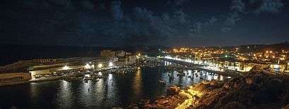
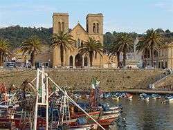 The old fishing harbor at El Kala facing the decommissioned Saint Cyprien Church |
 | |
 Algeria | |
| Location |
Cap Rosa El Kala Algeria |
|---|---|
| Coordinates | 36°56′47.27″N 8°14′12.53″E / 36.9464639°N 8.2368139°E |
| Year first constructed | 1906[1] |
| Foundation | concrete base |
| Construction | concrete tower |
| Tower shape | cylindrical tower with balcony and lantern |
| Markings / pattern | white tower, black lantern |
| Height | 15.30 metres (50.2 ft)[1] |
| Focal height | 132.30 metres (434.1 ft)[1] |
| Light source | main power |
| Range | 19 nautical miles (35 km; 22 mi)[1] |
| Characteristic | Fl (2) W 6s.[2] |
| Admiralty number | E6484 |
| NGA number | 22168 |
| ARLHS number | ALG-015[3] |
| Managing agent | Office Nationale de Signalisation Maritime |
El Kala (Arabic: القالة, French: formerly La Calle, Latin Thinisa in Numidia) is a seaport of Algeria, in El Tarf Province, 56 miles (90 km) by rail east of Annaba and 10 miles (16 km) west of the Tunisian frontier. It is the centre of the Algerian and Tunisian coral fisheries and has an extensive industry in the curing of sardines. The harbor is small and exposed to the northeast and west winds.
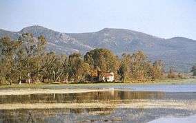
El Kala attracts tourists from within and outside the country, especially during the summer. It is home to an exceptional ecosystem and was declared a biosphere reserve by UNESCO in 1990.[4]
History
Thinisa in Numidia was an Ancient city in the Roman province of Numidia. It was important enough to become a bishopric. The old fortified town was built on a rocky peninsula about 400 metres long, connected with the mainland by a sand bank.
French and Italian coral fishing companies were interested in the area from as early as 1553. A trade bastion called "Bastion de France" by its Corsican founders was established during that period principally for the exploitation of red coral and also to facilitate trade between southern France and that part of northern Algeria. The bastion was shut down and returned to the rule of the Bey of Constantine in 1816.
After the occupation of La Calle by the French in 1836, a new town was built up along the coast.
Titular see of Thinisa in Numidia
In 1933, the Ancient diocese of Thinisa in Numidia was nominally restored as a Catholic titular see of the lowest (episcopal) rank.
Coordinates: 36°54′N 8°27′E / 36.900°N 8.450°E
It has had the following incumbents:
- Francesco Venanzio Filippini, Friars Minor (O.F.M.) (1933.05.23 – 1973.03.31)
- Mario Revollo Bravo (1973.11.13 – 1978.02.28) (later Cardinal)
- Javier Lozano Barragán (1979.06.05 – 1984.10.28) (later Cardinal)
- Mario Picchi, Salesians (S.D.B.) (1989.06.19 – 1997.03.29)
- Vincenzo Pelvi (1999.12.11 – 2006.10.14) (later Archbishop of Foggia–Bovino)
- Laurent Chu Văn Minh, Auxiliary Bishop of Hanoi (Vietnam) (2008.10.15 – Present) .
See also
References
- 1 2 3 4 "Cap Rosa". Office Nationale de Signalisation Maritime. Ministere des Travaux Publics. Retrieved 4 May 2017.
- ↑ List of Lights, Pub. 113: The West Coasts of Europe and Africa, the Mediterranean Sea, Black Sea and Azovskoye More (Sea of Azov) (PDF). List of Lights. United States National Geospatial-Intelligence Agency. 2015.
- ↑ "Eastern Algeria". The Lighthouse Directory. University of North Carolina at Chapel Hill. Retrieved 4 May 2017.
- ↑ http://www.unesco.org/new/en/natural-sciences/environment/ecological-sciences/biosphere-reserves/africa/algeria/el-kala/
Sources
![]()
External links
| Wikimedia Commons has media related to El Kala. |
Capital: El Taref | ||
| Districts | 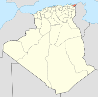 | |
| Communes | ||