El Cajon Mountain
| El Cajon Mountain | |
|---|---|
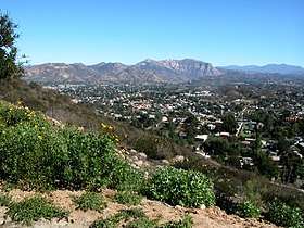 View of El Capitan looking east from Sky Ranch development in Santee | |
| Highest point | |
| Elevation | 3,648 ft (1,112 m) [1] |
| Prominence | 1,955 ft (596 m) [2] |
| Coordinates | 32°54′53″N 116°49′11″W / 32.9147711°N 116.8197465°WCoordinates: 32°54′53″N 116°49′11″W / 32.9147711°N 116.8197465°W [1] |
| Geography | |
| Location | San Diego County, California |
| Parent range | Cuyamaca Mountains |
El Cajon Mountain, commonly known as El Capitan or El cap, is a mountain in the Cuyamaca Mountains, and prominent natural landmark in the East County of San Diego.[3]
Geography
The summit of El Cajon Mountain is at 3648 feet (1112 m).[1] The mountain is almost completely surrounded by private property or an indian reservation,[4] but the mountain itself is mostly within the Cleveland National Forest or the County of San Diego’s El Capitan Open Space Preserve.[3]
Recreation
There are many different hikes and climbs up El Cajon Mountain, with difficulties ranging from a class 1 hike all the way up to a class 3 Scramble.[4] All the climbs are difficult due to the considerable elevation gain.[5] The trail head is located within the community of Lakeside, California.
Gallery
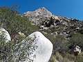 El Cajon Mountain Wall
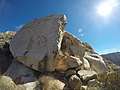 Lunch Rock on the middle of the south arete
See also
References
- 1 2 3 "GNIS Detail - El Cajon Mountain". Retrieved 30 October 2014.
- ↑ "El Cajon Mountain - peakbagger.com". Retrieved 30 October 2014.
- 1 2 "San Diego River Park Foundation". San Diego River Park Foundation. Retrieved 30 October 2014.
- 1 2 "El Cajon Mountain : SummitPost.org : Climbing, hiking, mountaineering". SummitPost.org. Retrieved 30 October 2014.
- ↑ "Hiking up to El Cajon Mountain Peak in the El Capitan Preserve". Retrieved 30 October 2014.