Ein al-Beida
| Ein al-Beida | |
|---|---|
| Other transcription(s) | |
| • Arabic | عين البيضا |
| • Also spelled |
Ayn al-Bayda (official) 'Ayn al-Baydah (unofficial) |
 Ein al-Beida | |
 Ein al-Beida Location of Ein al-Beida within Palestine | |
| Coordinates: 32°22′50″N 35°30′28″E / 32.38056°N 35.50778°ECoordinates: 32°22′50″N 35°30′28″E / 32.38056°N 35.50778°E | |
| Palestine grid | 197/198 |
| Governorate | Tubas |
| Founded | 1952 |
| Government | |
| • Type | Village council (from 1996) |
| Area | |
| • Jurisdiction | 15,000 dunams (15.0 km2 or 5.8 sq mi) |
| Population (2006) | |
| • Jurisdiction | 1,050 |
| Name meaning | "The White Spring"[1] |
Ein al-Beida (Arabic: عين البيضا) is a Palestinian village of in the Tubas Governorate in the northeastern West Bank. It has a population of about 1,050.
History
Ceramics from the Byzantine era have been found here.[2]
Ein al-Beida was reestablished in 1952 by Arab farmers belonging to the Fuquha and Daraghmah families from nearby Tubas who owned farms in the area and decided to establish a village. The village is named after a large spring in the area, Ein al-Beida, which was once used to irrigate the neighboring land.[3]
Geography and climate
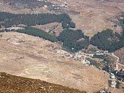
Ein al-Beida is situated in a plain area on the eastern foothill of the Jordan Valley surrounded by hills and mountains. It is located 15 kilometers northeast of Tubas, bordered by the Jordan River to the east, Bardala to the west, the Green Line to the north and the Israeli settlement of Mehola to the south. The town's elevation is 166 meters below sea level.[4]
The total jurisdiction of the village is 15,000 dunams, constituting 3% of the Tubas Governorate's land. Built-up area accounts for 480 dunams while 8,500 dunams are agricultural or cultivated lands.[4]
Warm weather is characteristic of Ein al-Beida, with hot, dry summers and cold and dry winters. The average rainfall in the village 275 millimeters. The average annual temperature is 21-22 degrees Celsius and the humidity rate is 55%.[4]
Demographics
Ein al-Beida's population in 1961 was 573, increasing to 791 in 1997. According to a census by the Palestinian Central Bureau of Statistics (PCBS) in that year, 398 were males and 393 were females. The census also revealed that 42.9% of the inhabitants were younger than 15, 54.1% between the ages of 15 and 64 and 3% above the age of 64.[5] In 2006, Ein al-Beida's population was 1,048.[6] The Fuquha family represent about 80% of the village residents while the Daraghma represent roughly 20%.[4]
Government
A village council was established in 1996 to govern Ein al-Beida. It consists of 7 members, including a chairman and holds elections every four years. Responsibilities of the council include administration, planning and development, social services, infrastructural maintenance and utilities.[4]
References
- ↑ Palmer, 1881, p. 197
- ↑ Dauphin, 1998, p. 790
- ↑ Conder and Kitchener, 1882, SWP II, p. 226
- 1 2 3 4 5 Ein al-Beida Village Profile Applied Research Institute - Jerusalem. February 2006.
- ↑ Palestinian Population by Locality, Sex and Age Groups in Years Palestinian Central Bureau of Statistics.
- ↑ Projected Mid -Year Population for Tubas District by Locality 2004- 2006 Archived 2008-04-24 at the Wayback Machine. Palestinian Central Bureau of Statistics.
Bibliography
- Conder, C.R.; Kitchener, H.H. (1882). The Survey of Western Palestine: Memoirs of the Topography, Orography, Hydrography, and Archaeology. 2. London: Committee of the Palestine Exploration Fund.
- Dauphin, Claudine (1998). La Palestine byzantine, Peuplement et Populations. BAR International Series 726 (in French). III : Catalogue. Oxford: Archeopress. ISBN 0-860549-05-4.
- Palmer, E.H. (1881). The Survey of Western Palestine: Arabic and English Name Lists Collected During the Survey by Lieutenants Conder and Kitchener, R. E. Transliterated and Explained by E.H. Palmer. Committee of the Palestine Exploration Fund.
External links
- Ein el Beida (Fact Sheet), Applied Research Institute–Jerusalem (ARIJ) February, 2006
- Ein el Beida village profile, ARIJ
- Survey of Western Palestine, Map 12: IAA, Wikimedia commons
