Edwardsport, Indiana
| Edwardsport, Indiana | |
|---|---|
| Town | |
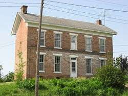 The Alfred Simonson House, a historic site in the town | |
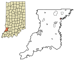 Location of Edwardsport in Knox County, Indiana. | |
| Coordinates: 38°48′41″N 87°15′6″W / 38.81139°N 87.25167°WCoordinates: 38°48′41″N 87°15′6″W / 38.81139°N 87.25167°W | |
| Country | United States |
| State | Indiana |
| County | Knox |
| Township | Vigo |
| Area[1] | |
| • Total | 0.28 sq mi (0.72 km2) |
| • Land | 0.28 sq mi (0.72 km2) |
| • Water | 0.00 sq mi (0.00 km2) |
| Elevation | 502 ft (153 m) |
| Population (2010)[2] | |
| • Total | 303 |
| • Estimate (2016)[3] | 298 |
| • Density | 1,068.10/sq mi (413.01/km2) |
| Time zone | UTC-5 (EST) |
| • Summer (DST) | UTC-4 (EDT) |
| ZIP code | 47528 |
| Area code(s) | 812 |
| FIPS code | 18-20458[4] |
| GNIS feature ID | 0434033[5] |
Edwardsport is a town in Vigo Township, Knox County, Indiana, United States. The population was only 303 at the 2010 census. It was founded in 1832 and named after Edward Wilkins,[6] a founding father.
History
Alfred Simonson House was added to the National Register of Historic Places in 2009.[7]
Geography
Edwardsport is located at 38°48′41″N 87°15′6″W / 38.81139°N 87.25167°W (38.811322, -87.251670).[8]
According to the 2010 census, Edwardsport has a total area of 0.28 square miles (0.73 km2), all land.[9]
Climate
The climate in this area is characterized by hot, humid summers and generally mild to cool winters. According to the Köppen Climate Classification system, Edwardsport has a humid subtropical climate, abbreviated "Cfa" on climate maps.[10]
Demographics
| Historical population | |||
|---|---|---|---|
| Census | Pop. | %± | |
| 1880 | 777 | — | |
| 1890 | 670 | −13.8% | |
| 1960 | 533 | — | |
| 1970 | 482 | −9.6% | |
| 1980 | 459 | −4.8% | |
| 1990 | 380 | −17.2% | |
| 2000 | 363 | −4.5% | |
| 2010 | 303 | −16.5% | |
| Est. 2016 | 298 | [3] | −1.7% |
| U.S. Decennial Census[11] | |||
2010 census
As of the census[2] of 2010, there were 303 people, 128 households, and 87 families residing in the town. The population density was 1,082.1 inhabitants per square mile (417.8/km2). There were 169 housing units at an average density of 603.6 per square mile (233.1/km2). The racial makeup of the town was 98.3% White, 0.3% Pacific Islander, 0.7% from other races, and 0.7% from two or more races. Hispanic or Latino of any race were 1.7% of the population.
There were 128 households of which 25.8% had children under the age of 18 living with them, 52.3% were married couples living together, 10.2% had a female householder with no husband present, 5.5% had a male householder with no wife present, and 32.0% were non-families. 29.7% of all households were made up of individuals and 10.9% had someone living alone who was 65 years of age or older. The average household size was 2.37 and the average family size was 2.85.
The median age in the town was 45.2 years. 19.5% of residents were under the age of 18; 6.3% were between the ages of 18 and 24; 23.5% were from 25 to 44; 35.6% were from 45 to 64; and 15.2% were 65 years of age or older. The gender makeup of the town was 50.8% male and 49.2% female.
2000 census
As of the census[4] of 2000, there were 363 people, 151 households, and 104 families residing in the town. The population density was 1,305.3 people per square mile (500.6/km²). There were 170 housing units at an average density of 611.3 per square mile (234.4/km²). The racial makeup of the town was 97.80% White, 0.55% African American, 0.28% Native American, and 1.38% from other races. Hispanic or Latino of any race were 1.65% of the population.
There were 151 households out of which 31.8% had children under the age of 18 living with them, 56.3% were married couples living together, 7.9% had a female householder with no husband present, and 31.1% were non-families. 27.8% of all households were made up of individuals and 14.6% had someone living alone who was 65 years of age or older. The average household size was 2.40 and the average family size was 2.88.
In the town, the population was spread out with 22.9% under the age of 18, 10.5% from 18 to 24, 31.1% from 25 to 44, 24.0% from 45 to 64, and 11.6% who were 65 years of age or older. The median age was 37 years. For every 100 females, there were 100.6 males. For every 100 females age 18 and over, there were 104.4 males.
The median income for a household in the town was $26,750, and the median income for a family was $31,979. Males had a median income of $26,979 versus $17,917 for females. The per capita income for the town was $13,541. About 15.6% of families and 20.5% of the population were below the poverty line, including 38.5% of those under age 18 and 8.9% of those age 65 or over.
Power generation
The Edwardsport Power Station located to the south of the town provides energy to the region. The plant has two units totalling 160 megawatt capacity.[12] A report by the WWF in 2005 ranked it as the second most polluting power station in the industrialized world, in terms of the level of carbon dioxide produced per unit of electricity generated.[13]
A third IGCC unit, of 600 megawatts, is under construction. When it opens in 2011, units one and two are to be decommissioned.
See also
References
- ↑ "2016 U.S. Gazetteer Files". United States Census Bureau. Retrieved Jul 28, 2017.
- 1 2 "American FactFinder". United States Census Bureau. Retrieved 2012-12-11.
- 1 2 "Population and Housing Unit Estimates". Retrieved June 9, 2017.
- 1 2 "American FactFinder". United States Census Bureau. Archived from the original on 2013-09-11. Retrieved 2008-01-31.
- ↑ "US Board on Geographic Names". United States Geological Survey. 2007-10-25. Retrieved 2008-01-31.
- ↑ Gannett, Henry (1905). The Origin of Certain Place Names in the United States. Govt. Print. Off. p. 115.
- ↑ National Park Service (2010-07-09). "National Register Information System". National Register of Historic Places. National Park Service.
- ↑ "US Gazetteer files: 2010, 2000, and 1990". United States Census Bureau. 2011-02-12. Retrieved 2011-04-23.
- ↑ "G001 - Geographic Identifiers - 2010 Census Summary File 1". United States Census Bureau. Retrieved 2015-07-16.
- ↑ Climate Summary for Edwardsport, Indiana
- ↑ "Census of Population and Housing". Census.gov. Archived from the original on May 12, 2015. Retrieved June 4, 2015.
- ↑ "About IGCC Power Plants". The Energy Blog. Retrieved 2006-11-02.
- ↑ WWF Australia: Hazelwood tops international list of dirty power stations, Dated: 13 Jul 2005
Municipalities and communities of Knox County, Indiana, United States | ||
|---|---|---|
| Cities | ||
| Towns | ||
| Townships | ||
| CDPs | ||
| Other unincorporated communities |
| |