Ecker
| Ecker | |
|---|---|
 | |
| Location |
Saxony-Anhalt, Lower Saxony, |
| Physical characteristics | |
| Main source |
Eckersprung: Southwest of the Brocken in the Harz 893 m above sea level (NN) 51°N 10°E / 51°N 10°ECoordinates: 51°N 10°E / 51°N 10°E |
| River mouth |
North of Wiedelah into the Oker 124 m above sea level (NN) 51°N 10°E / 51°N 10°E |
| Length | 28.0 km (17.4 mi) [1] |
| Basin features | |
| Progression | Oker→ Aller→ Weser→ North Sea |
| Basin size | 76.1 km2 (29.4 sq mi) [1] |
| Landmarks |
|
| Tributaries |
|
| Waterbodies | Reservoirs: Ecker Reservoir |
The Ecker is a 28-kilometre (17 mi), right-hand, southeast tributary of the Oker which runs mainly through the Harz mountains in the German states of Saxony-Anhalt and Lower Saxony.
Course
From its source to Abbenrode the Ecker is a border river, today running between the federal states of Saxony-Anhalt and Lower Saxony. Prior to German reunification this was also the border between the German Democratic Republic in the east and Federal Republic of Germany to the west.
The Ecker rises around 2.5 kilometres (1.6 mi) southwest of the Brocken at 890 m above sea level (NN) at the Eckersprung. Until the border was reopened it was the end of the Goethe Way (Goetheweg) from Torfhaus. Today there is a large picnic area with toilets at the Eckersprung.
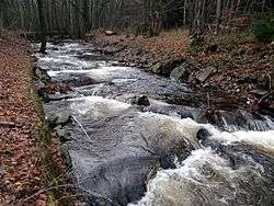
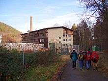
Along a steep, rocky bed, the Ecker initially flows to the Ecker Dam, then through the deeply incised Ecker valley towards the north-northeast, where it passes the Ahlsburg, and then leaves the Harz. The upper Ecker valley is part of the Harz National Park. Only the site of the paper factory, located there since the 19th century, was excluded.
Next, the Ecker runs via Stapelburg to Abbenrode (Nordharz district) before emptying later into the Oker, a tributary of the Aller, just north of Wiedelah (Vienenburg district) on the A 395 motorway at about 120 m above NN. Before Wiedelah some of the water is diverted as the Ecker Ditch (Eckergraben) and only feeds back into the Oker 10 kilometres (6 mi) north of Schladen.