Eastern Province, Rwanda
| Eastern Province Intara y'Iburasirazuba | |
|---|---|
| Province | |
 | |
| Country | Rwanda |
| Capital | Rwamagana |
| Districts | |
| Government | |
| • Governor | Fred Mufulukye (2017-) |
| Area[1] | |
| • Total | 9,813 km2 (3,789 sq mi) |
| Population (15 August 2012)[2] | |
| • Total | 2,600,812 |
| • Density | 275/km2 (710/sq mi) |
| Other settlements | Kibungo, Nyagatare, Nyamata, Gahini, Kabarore, Kagitumba |
Eastern Province (Kinyarwanda: Intara y'Iburasirazuba; French: Province de l'Est) is the largest, the most populous and the least densely populated of Rwanda's five provinces. It was created in early January 2006 as part of a government decentralization program that re-organized the country's local government structures.
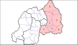
It has seven districts: Bugesera, Gatsibo, Kayonza, Ngoma, Kirehe, Nyagatare and Rwamagana. The capital city of the Eastern Province is Rwamagana.
The Eastern Province comprises the former provinces of Kibungo and Umutara, most of Kigali Rural, and part of Byumba.
History
It is not known when the territory of present day Rwanda was first inhabited, but it is thought that humans moved into the area following the last ice age either in the Neolithic period, around ten thousand years ago, or in the long humid period which followed, up to around 3000 BC.[3][4] Archaeological excavations have revealed evidence of sparse settlement by hunter gatherers in the late stone age, followed by a larger population of early Iron Age settlers, who produced dimpled pottery and iron tools.[3][5][6] By the 17th century it is thought that most of Rwanda was inhabited, with a fairly even spread of population across the hills of the country.[7]
List of the Eastern Province Districts by Population (2012) [8]
| Rank in Eastern Province Districts, 2012 |
Rank in Rwanda Districts, 2012 |
District |
Population 15 August 2012 |
Population, 15 August 2002 |
Population Change 2002-2012 (%) |
Population Density 2012 (km2) |
Population Density Rank, Eastern Province 2012 |
|---|---|---|---|---|---|---|---|
| 1 | 2 | Nyagatare | 466,944 | 255,104 | 83.0 | 243 | 6 |
| 2 | 3 | Gatsibo | 433,997 | 283,456 | 53.1 | 275 | 5 |
| 3 | 9 | Bugesera | 363,339 | 266,775 | 36.2 | 282 | 4 |
| 4 | 10 | Kayonza | 346,751 | 209,723 | 65.3 | 179 | 7 |
| 5 | 13 | Ngoma | 340,983 | 235,109 | 44.0 | 390 | 2 |
| 6 | 15 | Kirehe | 338,562 | 229,468 | 48.6 | 288 | 3 |
| 7 | 26 | Rwamagana | 310,238 | 220,502 | 40.7 | 455 | 1 |
| Total | - | Eastern Province | 2,660,814 | 1,700,137 | 53.0 | 275 | - |
Notes and references
- ↑ Area Calculation (see below)
- ↑ MINALOC
- 1 2 Briggs and Booth 2006 p6
- ↑ Chrétien p44
- ↑ Dorsey p36
- ↑ Chrétien p45
- ↑ Vansina p16
- ↑ "Archived copy". Archived from the original on 6 December 2012. Retrieved 6 December 2012.
Cited texts
- Briggs, Philip & Booth, Janice (2006) Rwanda - The Bradt Travel Guide. 3rd ed. London: Bradt Travel Guides. ISBN 1-84162-180-3
- Chrétien, Jean-Pierre (2003) The Great Lakes of Africa: Two Thousand Years of History Hardcover ed. Cambridge, MA: MIT Press. ISBN 1-890951-34-X
- Dorsey, Learthen (1994) Historical Dictionary of Rwanda. Scarecrow Press. ISBN 0-8108-2820-0
- Ministry of Local Government, Republic of Rwanda (MINALOC): "Eastern Province". Performance contracts in Year 2009-2010 (July 2009-June 2010). Accessed on 2010-03-11.
- Munyakazi, Augustine & Ntagaramba, Johnson Funga (2005). Atlas of Rwanda French ed. Oxford: Macmillan Education. ISBN 0-333-95451-3
Area calculation
- Pixel sizes for provinces taken from traced maps: North = 28,547; East = 81,548; South = 50,844; West = 51,798; Kigali = 6,129
- Total Pixel size for Rwanda = 28,547 + 81,548 + 50,844 + 51,798 + 6,129 = 218,866
- => Eastern Province % of total area: 81,548 / 218,866 = 37.26%
- Total area of Rwanda = 26,338 km2 (10,169 sq mi)
- "Rwanda". The World Facebook. United States Central Intelligence Agency. 4 March 2010. Accessed 11 March 2010.
- => Area of Eastern Province = 26,338 km2 (10,169 sq mi) x 37.26% = 9,813 km2 (3,789 sq mi)