East Pharsalia, New York
| East Pharsalia, New York | |
|---|---|
| Hamlet | |
 East Pharsalia, New York  East Pharsalia, New York | |
| Coordinates: 42°33′29″N 75°43′02″W / 42.55806°N 75.71722°WCoordinates: 42°33′29″N 75°43′02″W / 42.55806°N 75.71722°W | |
| Country | United States |
| State | New York |
| County | Chenango |
| Elevation | 1,591 ft (485 m) |
| Time zone | UTC-5 (Eastern (EST)) |
| • Summer (DST) | UTC-4 (EDT) |
| ZIP code | 13758 |
| Area code(s) | 607 |
| GNIS feature ID | 949204[1] |
East Pharsalia is a hamlet in Chenango County, New York, United States. The community is 10 miles (16 km) west of Norwich. East Pharsalia had a post office from March 10, 1830 until September 28, 2002; it still has its own ZIP code, 13758.[2][3]
References
- ↑ "East Pharsalia". Geographic Names Information System. United States Geological Survey.
- ↑ United States Postal Service. "USPS - Look Up a ZIP Code". Retrieved October 7, 2017.
- ↑ "Postmaster Finder - Post Offices by ZIP Code". United States Postal Service. Retrieved October 7, 2017.
Municipalities and communities of Chenango County, New York, United States | ||
|---|---|---|
| City | 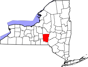 | |
| Towns | ||
| Villages | ||
| CDPs | ||
| Hamlets | ||
| Footnotes | ‡This populated place also has portions in an adjacent county or counties | |
This article is issued from
Wikipedia.
The text is licensed under Creative Commons - Attribution - Sharealike.
Additional terms may apply for the media files.