East Parsonsfield, Maine
| East Parsonsfield, Maine | |
|---|---|
| Village | |
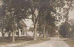 East Parsonsfield in 1917 | |
 East Parsonsfield | |
| Coordinates: 43°44′00″N 70°50′36″W / 43.73333°N 70.84333°WCoordinates: 43°44′00″N 70°50′36″W / 43.73333°N 70.84333°W | |
| Country | United States |
| State | Maine |
| County | York |
| Elevation | 643 ft (196 m) |
| Time zone | UTC-5 (Eastern (EST)) |
| • Summer (DST) | UTC-4 (EDT) |
| ZIP code | 04028 |
| Area code(s) | 207 |
| GNIS feature ID | 565653[1] |
East Parsonsfield is an unincorporated village in the town of Parsonsfield, York County, Maine, United States. The community is located along Maine State Route 160 near the town's eastern border with Cornish. East Parsonsfield has a post office with ZIP code 04028.[2][3]
References
- ↑ "East Parsonsfield". Geographic Names Information System. United States Geological Survey.
- ↑ United States Postal Service. "USPS - Look Up a ZIP Code". Retrieved July 26, 2015.
- ↑ "Postmaster Finder - Post Offices by ZIP Code". United States Postal Service. Retrieved July 26, 2015.
Municipalities and communities of York County, Maine, United States | ||
|---|---|---|
| Cities | 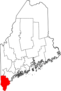 | |
| Towns | ||
| CDPs | ||
| Other villages | ||
This article is issued from
Wikipedia.
The text is licensed under Creative Commons - Attribution - Sharealike.
Additional terms may apply for the media files.