East Fork Kaweah River
| East Fork Kaweah River | |
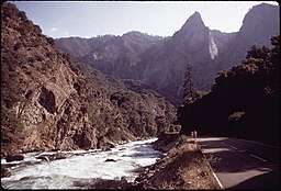 East Fork Kaweah River and Mineral King Road | |
| Country | United States |
|---|---|
| State | California |
| Source | Mineral King |
| - location | Sequoia National Park |
| - elevation | 10,029 ft (3,057 m) |
| - coordinates | 36°24′05″N 118°35′28″W / 36.40139°N 118.59111°W [1] |
| Mouth | Kaweah River |
| - location | Three Rivers |
| - elevation | 1,283 ft (391 m) |
| - coordinates | 36°28′45″N 118°50′18″W / 36.47917°N 118.83833°W [1] |
| Length | 22.5 mi (36 km) [2] |
| Basin | 95.3 sq mi (247 km2) [2] |
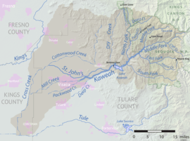 Map of the Kaweah River drainage basin | |
The East Fork Kaweah River is a 22.5-mile (36.2 km)[2] tributary of the Kaweah River in Tulare County, California. The river begins below Farewell Gap at the head of the Mineral King Valley in Sequoia National Park. It flows north through mountain meadows then turns west through a steep canyon, where it forms a waterfall about 200 feet (61 m) high known alternately as "Mineral King Falls" or "Three-Falls-Below-The-Gate".[3] It then receives its largest tributary, Horse Creek, from the left before leaving the national park and turning northwest. It joins the Kaweah River about 2 miles (3.2 km) upstream of Three Rivers.
The narrow, winding one-lane Mineral King Road runs along the East Fork canyon, providing the only vehicular access to Mineral King.
See also
References
- 1 2 "East Fork Kaweah River". Geographic Names Information System. United States Geological Survey. 1981-01-19. Retrieved 2018-05-21.
- 1 2 3 "National Hydrography Dataset via National Map Viewer". U.S. Geological Survey. Retrieved 2018-05-21.
- ↑ "Three-Falls-Below-The-Gate". World Waterfall Database. Retrieved 2018-05-21.