East–West Corridor
| East-West Corridor | |
|---|---|
| Metropolitan Area | |
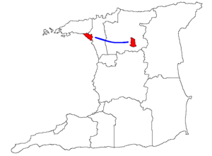 Approximate location of East–West Corridor in blue, with Port of Spain and Arima in red. | |
| Country |
|
| Area | |
| • Land | 899 km2 (347 sq mi) |
| Population (2011)[1] | |
| • Total | 546,014 |
| • Density | 607/km2 (1,570/sq mi) |
| Combined population of Port of Spain, Arima, Diego Martin, Tunapuna-Piarco, San Juan–Laventille | |
| Time zone | UTC-4 (AST) |
| Postal Code | 10xxxx - 36xxxx |
| Area code(s) | 868 |
The East–West Corridor is the built-up area of north Trinidad stretching from the capital, Port of Spain, 24 kilometres (15 mi) east to Arima. The term was coined by economist and political philosopher Lloyd Best, after gleaning the works of a technocrat named Lynette Attwell. The Corridor includes such towns as Laventille, Morvant, Barataria, San Juan, St. Joseph, Curepe, St. Augustine, Tunapuna, Tacarigua, Arouca, and Five Rivers, once distinct communities, now districts within a continuous urban area. For the most part it runs along the Eastern Main Road, between the Churchill–Roosevelt Highway and the foothills of the Northern Range. It is a densely populated and fairly congested strip of development along some of the best agricultural soils in the country. Over 548,000 Trinidadians live in the densely populated strip. This makes it the seventh largest metropolitan area in the West Indies.
Gallery
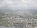 Looking west over the corridor.
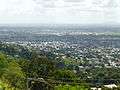 From front to back: Tunapuna, El Dorado, Tacarigua.
References