Eagle River, Michigan
| Eagle River, Michigan | |
|---|---|
| Unincorporated community | |
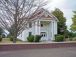 The Keweenaw County courthouse in Eagle River | |
 Eagle River, Michigan | |
| Coordinates: 47°24′50″N 88°17′44″W / 47.41389°N 88.29556°WCoordinates: 47°24′50″N 88°17′44″W / 47.41389°N 88.29556°W[1] | |
| Country | United States |
| State | Michigan |
| County | Keweenaw |
| Area[2] | |
| • Total | 5.964 sq mi (15.45 km2) |
| • Land | 5.945 sq mi (15.40 km2) |
| • Water | 0.019 sq mi (0.05 km2) |
| Elevation[1] | 650 ft (200 m) |
| Population (2010)[2] | |
| • Total | 71 |
| • Density | 12/sq mi (4.6/km2) |
| Time zone | UTC-5 (Eastern (EST)) |
| • Summer (DST) | UTC-4 (EDT) |
| Area code(s) | 906 |
| GNIS feature ID | 625096[1] |
Eagle River is an unincorporated community and census-designated place in the U.S. state of Michigan and is the county seat of Keweenaw County.[3] Its population was 71 as of the 2010 census.[2]
The community is on M-26 on the north side of the Keweenaw Peninsula, which projects northwards into Lake Superior. It is about 27 miles northeast of Houghton and is situated in the northwest corner of Houghton Township on the mouth of the Eagle River at 47°24′50″N 88°17′45″W / 47.41389°N 88.29583°W. The ZIP code is 49950.
Eagle River was a boom town of the copper mining era in the Keweenaw. Copper was discovered in 1845 at the Cliff Range nearby, the so-called "Cliff Lode". The land of the Eagle River community had been leased by the Keweenaw Copper Company in 1843. It was later platted by the Phoenix Company and sold as individual lots. The first postmaster was named on October 24, 1845. It was part of Houghton County until Keweenaw County was organized in 1861. The profitability of the area's copper mines had begun to decline sharply by around 1870.
The decommissioned Eagle River Lighthouse is on the west bank of the river on a sand bluff overlooking Lake Superior, although the view is partially obscured by condominiums.
The Eagle River Timber Bridge is a wooden arch bridge that carries highway M-26 over the Eagle River. It opened in 1990 as a replacement for the historic Lake Shore Drive Bridge that runs parallel to it.
Eagle River is home to the Holy Transfiguration Skete, a Byzantine Catholic monastery and community, which is known for producing jams and other foodstuffs from berries collected in the nearby forests. Holy Transfiguration is one of only a few Byzantine Catholic monasteries in the United States.
Transportation
References
- 1 2 3 "Eagle River". Geographic Names Information System. United States Geological Survey.
- 1 2 3 "2010 Census Gazetteer Files - Places: Michigan". U.S. Census Bureau. Retrieved August 1, 2017.
- ↑ "Find a County". National Association of Counties. Archived from the original on 2012-07-12. Retrieved 2011-06-07.
Municipalities and communities of Keweenaw County, Michigan, United States | ||
|---|---|---|
| Village | 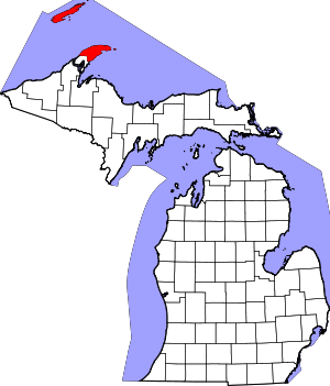 | |
| Townships | ||
| CDPs | ||
| Other unincorporated communities | ||
| Ghost towns | ||