Dusty Star Mountain
| Dusty Star Mountain | |
|---|---|
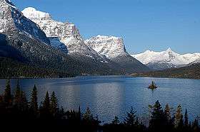 Dusty Star Mountain is in center of image, above and slightly left of Wild Goose Island in Saint Mary Lake | |
| Highest point | |
| Elevation | 8,573 ft (2,613 m) [1] |
| Prominence | 573 ft (175 m) [1] |
| Coordinates | 48°39′01″N 113°33′07″W / 48.65028°N 113.55194°WCoordinates: 48°39′01″N 113°33′07″W / 48.65028°N 113.55194°W [2] |
| Geography | |
 Dusty Star Mountain | |
| Parent range | Lewis Range |
| Topo map | USGS Logan Pass, MT |
Dusty Star Mountain (8,573 feet (2,613 m)) is located in the Lewis Range, Glacier National Park in the U.S. state of Montana.[3] Connected by an arête to Citadel Mountain to the south, Dusty Star Mountain lies to the south and across the Saint Mary Valley from Going-to-the-Sun Mountain. Dusty Star Mountain is easily seen from the Going-to-the-Sun Road, and often photographed by tourists taking pictures of Wild Goose Island which lies in the western section of Saint Mary Lake. The Blackfoot name for Dusty Star is iszika-kakatosi meaning "meteor" or "smoking star".[4]
See also
References
- 1 2 "Dusty Star Mountain High Point, Montana". Peakbagger.com. Retrieved July 28, 2017.
- ↑ "Dusty Star Mountain". Geographic Names Information System. United States Geological Survey. Retrieved July 28, 2017.
- ↑ Logan Pass, MT (Map). TopoQwest (United States Geological Survey Maps). Retrieved July 28, 2017.
- ↑ Ashley, John (June 15, 2015). Glacier National Park After Dark: Sunset to Sunrise in a Beloved Montana Wilderness. John Ashley Fine Art Photography. p. 48. ISBN 978-1591521600.
This article is issued from
Wikipedia.
The text is licensed under Creative Commons - Attribution - Sharealike.
Additional terms may apply for the media files.