Dunswell
| Dunswell | |
|---|---|
 Dunswell Dunswell shown within the East Riding of Yorkshire | |
| OS grid reference | TA073351 |
| • London | 155 mi (249 km) S |
| Civil parish | |
| Unitary authority | |
| Ceremonial county | |
| Region | |
| Country | England |
| Sovereign state | United Kingdom |
| Post town | HULL |
| Postcode district | HU6 |
| Dialling code | 01482 |
| Police | Humberside |
| Fire | Humberside |
| Ambulance | Yorkshire |
| EU Parliament | Yorkshire and the Humber |
| UK Parliament | |
Dunswell is a village in the East Riding of Yorkshire, England, and in the civil parish of Woodmansey.
Historically also known as Beer-Houses due to the presence of two Inns in close proximity, the village is located on the main Kingston upon Hull to Beverley road. A significant drinking water extraction works was opened in 1931 west of the village, helping to supplying Hull and the surrounding area.
Geography
Dunswell is situated at the junction of Dunswell Lane and A1174 road Hull to Beverley road approximately 4 and 3.5 miles (6.4 and 5.6 km) from the centres of Kingston upon Hull and Beverley respectively. It is approximately 440 yards (400 m) west of the River Hull; the Beverley and Barmston Drain also runs north-south, adjacent to the west of the village.
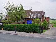
The village has a hall, Dunswell Village Institute;[2] and a primary school Dunswell Primary, since 2014 Dunswell Academy.[3]
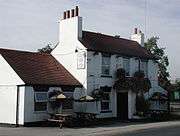
The Ship Inn is located at the junction of the main road and Ings Lane leading to Skidby Landing on the River Hull.[note 1]
Governance
The village was in the Beverley and Holderness parliamentary constituency until the 2010 general election when it was transferred to the constituency of Haltemprice and Howden.[1]
History

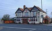
According to Charles Overton, Dunswell was once known as Douceville, a reference to its many springs and wells.[5] At one time it was also known as Beer-Houses due to the two public houses in close vicinity.[6][7] The two pubs in the village, The Coach and Horses (aka The Plough) and The Wagon and Horses,[note 2] are thought to originate from the 17th century. The Hull to Beverley road was turn-piked in 1741.[8]
An act allowing the construction of the Beverley and Skidby Drain was passed in 1785, and the Beverley and Barmston Drain allowed by an act of 1798.[note 3] in 1880 improvements to the lower reaches of the drainage system enabled further extraction, and a steam engine for drainage was installed at Dunswell for the Skidby Drain.[10] The drainage of the land reduced flooding, but caused some local wells to become dry.[8]
In around 1814 a non-conformist chapel ("Bethel") was built in the village for the Methodist New Connexion branch.[11] In the 1850s the village consisted of two Inns on the Hull and Beverley road, with the village west along Dunswell Lane, with fewer than twenty houses.[12] The village school opened in 1881.[8]
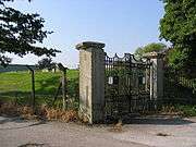
In 1893 the Newington Water Company gained authorisation to open a water supply works at Dunswell to replace a source at Swanland that had become contaminated by salt.[13] The company was taken over by the Hull Corporation shortly after.[14] In 1911 permission was given for additional water works at Dunswell, and after being halted by the First World War, they were restarted in 1923 on a larger scale – the water pumping station was opened in 1931.[15][note 4] The works included a 16 feet (4.9 m) diameter well, with 5,200 feet (1,600 m) of adits.[17] The works was one of the three main water supplies for the area, along with Springhead Pumping Station and Mill Dam in Cottingham.[18] The adit system was expanded in the early 1950s to meet demand from the borough of Beverley but the works did not yield an increase in supply.[19]
St Faiths Church of England church opened in 1951; the non-conformist chapel held its last service in 1968.[8]
Low level housing development took place in the second half of the 20th century, with houses on Ings Lane, and houses and new cul-de-sac streets south of the Dunwell Lane/Beverley Road junction (The Meadows, Dene Close).[20] In 1985 the village became part of the civil parish of Woodmansey.[21]
In 2013 Dunswell primary school was listed for closure by East Riding Council; the closure, which was opposed by many nearby residents was averted by transferring to academy status, as a subsidiary of the primary school in Swanland.[3]
Gallery
Notes
- ↑ There was once a ferry across the Hull at Dunswell (1913).[4]
- ↑ Replaced with houses.[8] demolished in the early 20th century,[9]
- ↑ The Skidby Drain passed east of the village, the much larger Barmston Drain west of the village.
- ↑ The main pumping station building was a white concrete structure resembling an Egyptian temple. (see Egyptian Revival architecture.) The above ground building was demolished in 1987.[16]
References
- 1 2 "Are you ready to vote in the next election?". East Riding News. East Riding of Yorkshire Council: p. 3. April 2010.
- ↑ "Dunswell Village Institute". www.ruralcommunitybuildings.org.uk. Retrieved 23 June 2014.
- 1 2 Sources:
- "Primary schools at Dunswell and Gembling face closure – and more could be at risk". Hull Daily Mail. 24 January 2013. Retrieved 23 June 2014.
- "Parents grill East Riding Council over closure of Dunswell Primary School". Hull Daily Mail. 15 March 2013. Retrieved 23 June 2014.
- "Saved: Dunswell Primary School to survive as academy". Hull Daily Mail. 13 August 2013. Retrieved 23 June 2014.
- ↑ Baggs, A.P.; Cooper, T.N.; Davidson-Cragoe, C.; Walker, J. (2002). "Wawne". In Allison, K.J.; Kent, G.H.R. Holderness Wapentake, Middle and North Divisions. A History of the County of York East Riding. 7.
- ↑ Overton, Charles (1861). The History of Cottingham. p. 10.
- ↑ Langdale, Thomas (1822). A Topographical Dictionary of Yorkshire: Containing the Names of All the Towns, Villages, Hamlets ... pp. 140, 156.
- ↑ Nicholson, John (1926). Place-names of the East Riding of Yorkshire. p. 35.
- 1 2 3 4 5 East Yorkshire Federation of Women's Institutes 1991.
- ↑ Ordnance Survey. 1909, 1926. Sheet 226.NW
- ↑ Sheppard 1976, p. 14, 21.
- ↑ Wollfe, John, ed. (2000). Introduction, City of York and East Riding. Yorkshire Returns of the 1851 Census of Religious Worship:. 1. University of York – Borthwick Institute. 359, p.57.
- ↑ Ordnance Survey. 1852-3. Sheet 226
- ↑ Aylwin & Ward 1969, p. 45.
- ↑ Allison, K.J., ed. (1969). "Water Supply". The City of Kingston upon Hull. A History of the County of York East Riding. 1.
- ↑ Jones 1955, pp. 388–391.
- ↑ Pevsner, Nikolaus; Neave, David (1995). Yorkshire: York and the East Riding. The Buildings of England (2nd ed.).
- ↑ Aylwin & Ward 1969, p. 46.
- ↑ Journal of the American Water Works Association: 798. 1948. Missing or empty
|title=(help) - ↑ Aylwin & Ward 1969, p. 47.
- ↑ Ordnance Survey. 1:10560, 1938–52; 1956; 1973–4; 1982–4; 1989–92
- ↑ Baggs, A.P.; Brown,, L.M.; Forster, G.C.F.; Hall, I.; Horrox, R.E.; Kent, G.H.R.; Neave, D. (1989). "Thearne and Woodmansey". In Allison, K.J. The borough and liberties of Beverley. A History of the County of York East Riding. 6.
Sources
- Gazetteer — A–Z of Towns Villages and Hamlets. East Riding of Yorkshire Council. 2006. p. 5.
- East Yorkshire Federation of Women's Institutes (1991). Dunswell. The East Yorkshire Village Book. Countryside Books. ISBN 1853061387.
- Aylwin, E.; Ward, R.C. (1969). Development and utilisation of water supplies in the East Riding of Yorkshire. University of Hull.
- Jones, T. H. (1955). "The Water Supply of Kingston Upon Hull from 1292 to 1954, and the Future Sources of Supply". The Journal of the Royal Society for the Promotion of Health. 75 (6): 386. doi:10.1177/146642405507500614.
- Sheppard, June A. (1976) [1958]. Allison, K.J., ed. The Draining of the Hull Valley (PDF). East Yorkshire Local History Series. East Yorkshire Local History Society.
External links

- "St Faith's Church, Dunswell". www.stjohnnewland.org.uk.
- "Dunswell Academy". www.dunswellacademy.co.uk.
- "Dunswell Water Pumping Station". www.flickr.com. , entrance detail