Dunmore, West Virginia
| Dunmore, West Virginia | |
|---|---|
| Unincorporated community | |
 Dunmore, West Virginia  Dunmore, West Virginia | |
| Coordinates: 38°21′34″N 79°52′51″W / 38.35944°N 79.88083°WCoordinates: 38°21′34″N 79°52′51″W / 38.35944°N 79.88083°W | |
| Country | United States |
| State | West Virginia |
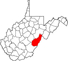
| County | Pocahontas |
| Elevation | 2,477 ft (755 m) |
| Time zone | UTC-5 (Eastern (EST)) |
| • Summer (DST) | UTC-4 (EDT) |
| ZIP code | 24934 |
| Area code(s) | 304 & 681 |
| GNIS feature ID | 1550994[1] |
Dunmore is an unincorporated community in Pocahontas County, West Virginia, United States. Dunmore is located at the junction of West Virginia Route 28 and West Virginia Route 92 15 miles (24 km) northeast of Marlinton. Dunmore has a post office with ZIP code 24934.[2]
Some say the community has the name of the Earl of Dunmore, while others believe the place's name is an amalgamation of Dunkum and Moore, early owners of the town site.[3]
Climate
The climate in this area has mild differences between highs and lows, and there is adequate rainfall year-round. According to the Köppen Climate Classification system, Dunmore has a marine west coast climate, abbreviated "Cfb" on climate maps.[4]
References
- ↑ "US Board on Geographic Names". United States Geological Survey. 2007-10-25. Retrieved 2008-01-31.
- ↑ ZIP Code Lookup
- ↑ Kenny, Hamill (1945). West Virginia Place Names: Their Origin and Meaning, Including the Nomenclature of the Streams and Mountains. Piedmont, WV: The Place Name Press. p. 218.
- ↑ Climate Summary for Dunmore, West Virginia
This article is issued from
Wikipedia.
The text is licensed under Creative Commons - Attribution - Sharealike.
Additional terms may apply for the media files.