Dryna
 | |
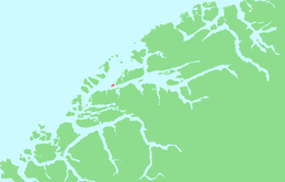 Location in Møre og Romsdal | |
| Geography | |
|---|---|
| Location | Romsdal, Norway |
| Coordinates | 62°38′43″N 6°31′49″E / 62.6454°N 6.5304°ECoordinates: 62°38′43″N 6°31′49″E / 62.6454°N 6.5304°E |
| Area | 1.7 km2 (0.66 sq mi) |
| Length | 2.5 km (1.55 mi) |
| Width | 1 km (0.6 mi) |
| Coastline | 6 km (3.7 mi) |
| Highest elevation | 200 m (700 ft) |
| Highest point | Drynjahatten |
| Administration | |
| County | Møre og Romsdal |
| Municipality | Midsund Municipality |
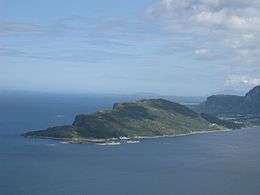
Dryna is an island in Midsund Municipality in Møre og Romsdal county, Norway. It is the westernmost of the main islands in the municipality. The 1.7-square-kilometre (0.66 sq mi) island sits between the Harøyfjorden and the Midfjorden, at the entrance to the great Romsdalsfjorden. Until 1965, Dryna was part of Haram Municipality.[1]
Dryna has a road connection to the neighboring island of Midøya to the east. There are ferry connections from the western end of the island to Brattvåg (in Haram Municipality) and Myklebost (in Sandøy Municipality).[2]
The name
The Old Norse form of the name was Dryn. The name is probably derived from the word drynr which means "rumble" or "roar" (referring to the swell of the waves against the island).
References
- ↑ Jukvam, Dag (1999). "Historisk oversikt over endringer i kommune- og fylkesinndelingen" (PDF) (in Norwegian). Statistisk sentralbyrå.
- ↑ "Dryna" (in Norwegian). yr.no. Retrieved 2010-10-23.
This article is issued from
Wikipedia.
The text is licensed under Creative Commons - Attribution - Sharealike.
Additional terms may apply for the media files.