Drury, Kansas
| Drury, Kansas | |
|---|---|
| Unincorporated community | |
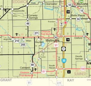 KDOT map of Sumner County (legend) | |
 Drury  Drury | |
| Coordinates: Coordinates: 37°02′08″N 97°28′40″W / 37.03556°N 97.47778°W | |
| Country | United States |
| State | Kansas |
| County | Sumner |
| Township | Falls |
| Time zone | UTC-6 (CST) |
| • Summer (DST) | UTC-5 (CDT) |
| Area code | 620 |
Drury is an unincorporated community in Falls Township, Sumner County, Kansas, United States. It is located between South Haven and Caldwell, next to the Chikaskia River.
History
Drury was a station and shipping point on the Kansas Southwestern Railway.[1]
Drury had a post office from 1884 until 1921.[2]
References
- ↑ Blackmar, Frank Wilson (1912). Kansas: A Cyclopedia of State History, Embracing Events, Institutions, Industries, Counties, Cities, Towns, Prominent Persons, Etc. Standard Publishing Company. p. 549.
- ↑ "Kansas Post Offices, 1828-1961". Kansas Historical Society. Archived from the original on October 9, 2013. Retrieved 27 June 2014.
External links
- Drury Dam in south Sumner County had one colorful history - Sumner News
- Drury Dam Waterfall - Kansas Travel
- Historic Images of Drury - Special Photo Collections at Wichita State University Library
- Sumner County Maps: Current, Historic - KDOT
Municipalities and communities of Sumner County, Kansas, United States | ||
|---|---|---|
| Cities | 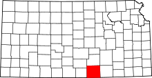 | |
| CDP | ||
| Unincorporated communities | ||
| Footnotes | ‡This populated place also has portions in an adjacent county or counties | |
This article is issued from
Wikipedia.
The text is licensed under Creative Commons - Attribution - Sharealike.
Additional terms may apply for the media files.