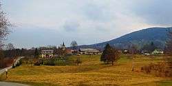
Drganja Sela
| Drganja Sela | |
|---|---|
 | |
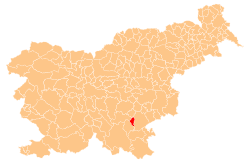
 Drganja Sela Location in Slovenia | |
| Coordinates: 45°44′49.98″N 15°5′28.5″E / 45.7472167°N 15.091250°ECoordinates: 45°44′49.98″N 15°5′28.5″E / 45.7472167°N 15.091250°E | |
| Country |
|
| Traditional region | Lower Carniola |
| Statistical region | Southeast Slovenia |
| Municipality | Straža |
| Area | |
| • Total | 5.4 km2 (2.1 sq mi) |
| Elevation | 284.1 m (932.1 ft) |
| Population (2002) | |
| • Total | 162 |
| [1] | |
Drganja Sela (pronounced [dəɾˈɡaːnja ˈseːla]; Slovene: Drganja sela) is a village in the Municipality of Straža in southeastern Slovenia. The area is part of the historical region of Lower Carniola. The municipality is now included in the Southeast Slovenia Statistical Region.[2]
The local church is dedicated to Mary, Comforter of the Afflicted and belongs to the Parish of Vavta Vas. It is a medieval building that was restyled in the Baroque in the early 18th century.[3]
References
- ↑ Statistical Office of the Republic of Slovenia
- ↑ Straža municipal site
- ↑ "EŠD 2631". Registry of Immovable Cultural Heritage (in Slovenian). Ministry of Culture of the Republic of Slovenia. Retrieved 14 March 2011.
External links
| Settlements | Administrative centre: Straža
|  | ||||
|---|---|---|---|---|---|---|
This article is issued from
Wikipedia.
The text is licensed under Creative Commons - Attribution - Sharealike.
Additional terms may apply for the media files.