Drei Höfe
| Drei Höfe | ||
|---|---|---|
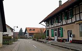 Heriswil main street | ||
| ||
 Drei Höfe | ||
|
Location of Drei Höfe 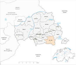 Drei Höfe Drei Höfe (Canton of Solothurn) | ||
| Coordinates: 47°10′N 7°38′E / 47.167°N 7.633°ECoordinates: 47°10′N 7°38′E / 47.167°N 7.633°E | ||
| Country | Switzerland | |
| Canton | Solothurn | |
| District | Wasseramt | |
| Area[1] | ||
| • Total | 4.58 km2 (1.77 sq mi) | |
| Population (Dec 2016[2]) | ||
| • Total | 731 | |
| • Density | 160/km2 (410/sq mi) | |
| Postal code | 4558 | |
| SFOS number | 2535 | |
| Surrounded by | Aeschi, Etziken, Halten, Horriwil, Oekingen | |
| Website |
www SFSO statistics | |

Drei Höfe is a municipality in the district of Wasseramt in the canton of Solothurn in Switzerland. On 1 January 2013 the former municipalities of Heinrichswil-Winistorf and Hersiwil merged to form the new municipality of Drei Höfe.[3]
History
Heinrichswil is first mentioned in 1317 as Cristan von Heinrichswile.[4]
Hersiwil is first mentioned in 1324 as Hersenwile. It formed a double municipality with Heinrichswil until 1798, when Winistorf joined the other two to form the triple municipality of Hersiwil-Heinrichswil-Winistorf. In 1854 it split into three, separate, independent municipalities. In 1993, Heinrichswil and Winistorf merged again, but Hersiwil remained independent.[5]
Geography
_120.JPG)
The former municipalities that now make up Drei Höfe have a total combined area of 4.58 km2 (1.77 sq mi).[1]
Heinrichswil-Winistorf had an area, as of 2009, of 3.13 square kilometers (1.21 sq mi). Of this area, 1.59 km2 (0.61 sq mi) or 50.8% is used for agricultural purposes, while 1.26 km2 (0.49 sq mi) or 40.3% is forested. Of the rest of the land, 0.25 km2 (0.097 sq mi) or 8.0% is settled (buildings or roads).[6] The former municipality is located on a hill built up from a moraine on the road between Halten and Seeberg. It consists of the villages of Heinrichswil and Winistorf.
Hersiwil had an area, as of 2009, of 1.43 square kilometers (0.55 sq mi). Of this area, 0.97 km2 (0.37 sq mi) or 67.8% is used for agricultural purposes, while 0.32 km2 (0.12 sq mi) or 22.4% is forested. Of the rest of the land, 0.09 km2 (22 acres) or 6.3% is settled (buildings or roads), 0.02 km2 (4.9 acres) or 1.4% is either rivers or lakes and 0.01 km2 (2.5 acres) or 0.7% is unproductive land.[6]
Demographics
The total population of Drei Höfe (as of December 2016) is 731.[2]
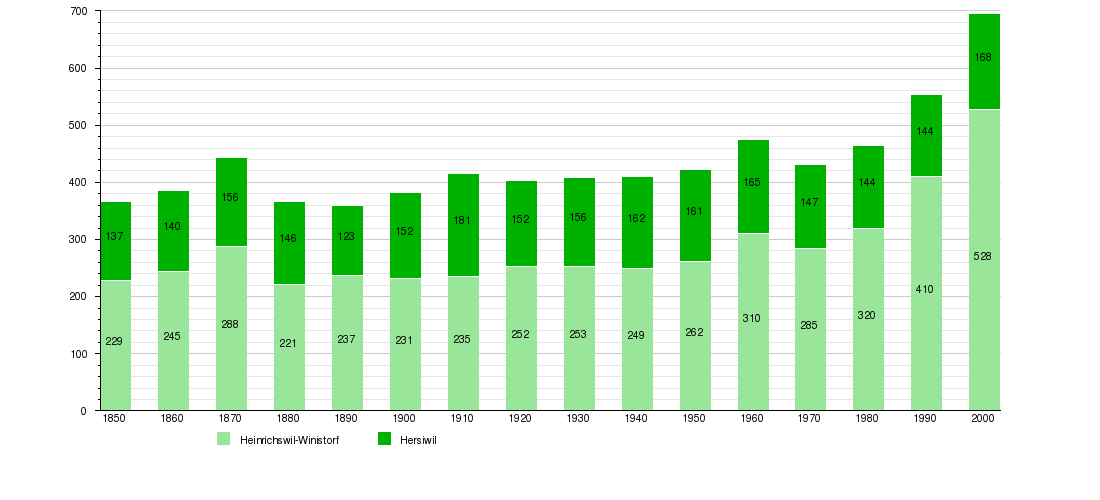
Historic Population
The historical population is given in the following chart:[7]
References
- 1 2 Arealstatistik Standard - Gemeindedaten nach 4 Hauptbereichen
- 1 2 Swiss Federal Statistical Office - STAT-TAB, online database – Ständige und nichtständige Wohnbevölkerung nach institutionellen Gliederungen, Geburtsort und Staatsangehörigkeit (in German) accessed 30 August 2017
- ↑ Amtliches Gemeindeverzeichnis der Schweiz published by the Swiss Federal Statistical Office (in German) accessed 2 January 2013
- ↑ Heinrichswil-Winistorf in German, French and Italian in the online Historical Dictionary of Switzerland.
- ↑ Hersiwil in German, French and Italian in the online Historical Dictionary of Switzerland.
- 1 2 Swiss Federal Statistical Office-Land Use Statistics 2009 data (in German) accessed 25 March 2010
- ↑ Federal Statistical Office STAT-TAB Bevölkerungsentwicklung nach Region, 1850-2000 Archived March 17, 2012, at the Wayback Machine. (in German) accessed 29 January 2011
External links
| Wikimedia Commons has media related to Drei Höfe. |
- Hersiwil in German, French and Italian in the online Historical Dictionary of Switzerland.
- Heinrichswil in German, French and Italian in the online Historical Dictionary of Switzerland.